
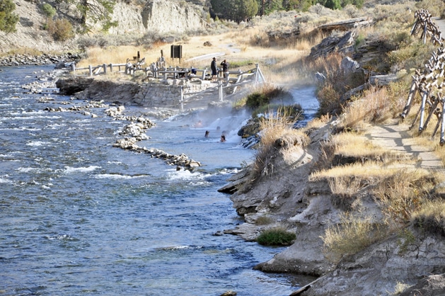
 Swimming area at the junction of the Boiling River and the Gardiner River. Bathers can pick the temperature of their choice. At the junction, water is very hot. Pools further down the Gardiner are successively cooler. Photo by Stephen Earl Williams
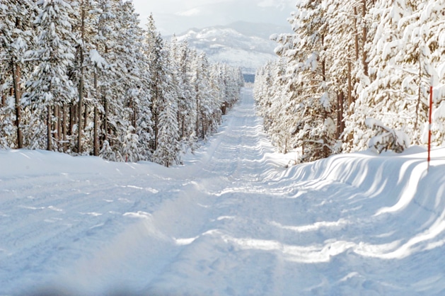 Winter view south along the road to the south gate of Yellowstone. The Teton Massive is on the far horizon. Photo by Stephen Earl Williams
By STEPHEN WILLIAMS
Yellowstone National Park
At 16, I was in Yellowstone National Park (YNP) for the first time with my family.
That was in 1964. We camped at Bridge Bay, rented a boat and fished in Yellowstone Lake, ate fish caught there, saw moose, elk, and thermal features. While in the park, our family stopped at Moose Falls on Crawfish Creek, which is just off the road a few miles into the Park from the South Entrance. It’s a beautiful falls, with a deep pool at the base and shards and stones of obsidian throughout the adjacent woods.
Two years later, I found myself on the maintenance crew out of Lake, and worked as a G-Man (garbage man) on a truck that picked up the trash and ashes at Fishing Bridge campground as well as Bridge Bay. We also collected the garbage at the Fishing Bridge Trailer Park, the cabin area at Fishing Bridge, the Lake hotel and various garbage containers along the road between Lake and Hayden Valley. In those days a major dump was located in Hayden Valley where we would unload our truck every afternoon. At the dump we saw lots of bears, all grizzly bears.
The view of life in Yellowstone Park from the back of a garbage truck is a little different than what most tourists or even the rangers experience. There were plenty of encounters with wildlife including bears. One of the skills learned was how to open a bear proof garbage can and also how to avoid interested bears. Still, most of the issues were concerned with removal of trash from containers and getting it into the opening in the back of the truck.
The Fishing Bridge campground garbage cans were an underground version. The 20 gallon pails that were the garbage receptacle were under fairly heavy lids. They had a handles for yanking them out of the ground. We established a routine where when the garbage truck slowly passed, I would jump off, remove the can from its hole in the ground and hand it to Cliff, my fellow worker. He would dump it and then slide it back to me and I would place it back in the hole and replace the lid. During this interval, Cliff would then run forward of the moving truck and lift the next can out of the hole and hand it to me, since by then I had caught up with the truck. I would dump it and slide it back to cliff. Then I would run forward to the next can. In this manner we would sort of leap frog through the various campground loops at fishing bridge, collecting the garbage quickly and efficiently.
The only glitch in the process was if one of the campground hosts had left a pile of fire place ashes for us to pick up. In such a case, we would grab our scoop shovels, load the ashes in the back of the truck, activate the packing mechanism to move the ashes into the cavernous hold of the truck, and then move on.
The whole garbage ballet, so to speak, required special attention of our driver, Charlie, to maintain a near constant speed as we emptied the garbage cans and of course to slow or nearly stop when we loaded ashes. Another function Charlie had was to be sure the truck radio was blasting out what ever music was available on the truck radio so that our garbage collecting ballet could be performed to something with a beat. The perfect song in those days was Bob Dylan’s “Rainy Day Women 12 and 35.” Swinging through the Fishing Bridge Campground, dumping, sliding, running to the next container and doing this to the near honkytonk sounds of Bob Dylan, was ethereal!
Picking up the garbage in the Fishing Bridge Cabin area presented a special challenge. The employees that maintained the cabins changing sheets, cleaning up between guests and general maintenance, often ambushed us as we moved through the cabin area. They had access to some pretty good ammunition, mostly eggs. However, we as G-Men, had access to a nearly unlimited supply of ammunition. Frequently at the Lake Hotel there would be rotten tomatoes in the garbage that we would sequester in a small bucket at the back end of the garbage truck.
Our war with the cabin attendees was pretty benign. However, one day we got pelted with grapefruits that were very much on the rotting side. After that, the skirmishes settled down for a while. However, we were late getting into the cabin area one day and I happened to discover three of the cabin attendees asleep in their truck in a little wooded area just outside of the cabin area proper. I came up on the passenger side of the truck. The side window was open. The guy nearest me was laid back against the seat. The fellow in the middle was sitting upright. The driver was draped over the steering wheel. I could see all three heads and faces. I happened to have a very large, very rotten tomato in my possession. Further, I happened to make the throw of a lifetime. I threw the tomato hard through the passenger’s open window. I saw it splat, splat, splat on all three faces, and I disappeared.
The next several days were rather horrendous in terms of ambushes, and especially odoriferous ammunition. A few tourists got caught in a cross fire one day. Apparently they reported the incident. There was feedback from the cabin supervisor as well as from our NPS supervisor. No names were mentioned, but it was clear that the end of the cabin wars was over at pain of dismissal.
For the next three summers I was part of the Blister Rust Control Crew. There were about a hundred of us at several locations in the park. Because we provided a quick and effective manpower sources, we were called out on numerous situations that included fire control, search and rescue, pine bark beetle survey, hazard tree removal and once for crowd control at a governor’s conference at Old Faithful. During a fourth of July snow storm we even helped campers pack and leave.
It was a great four summers in the Park. The natural beauty was always there, the food was good and plentiful from our mess hall, there was entertainment in West Yellowstone, Cody, and Jackson Hole. There were plenty of single women also working in the Park. A band made a circuit of the park and played weekly at Lake Lodge, Coulter Hall (in Canyon), or at Mammoth and Old Faithful.
I’ve been fortunate to have returned to Wyoming in 1976 as a faculty member at the University of Wyoming. I have had considerable work that has taken me to Yellowstone, including being a part of team to evaluate the ecological impacts of the 1988 Yellowstone Fires.
In the fall, after fires had been extinguished by snow, the team visited Yellowstone and we took helicopter trips over much of the burned area. I was lucky enough to be in a two passenger machine where my partner was Jack Ward Thomas, previous Chief of the Forest Service. We flew mostly in the Lamar River watershed and up Cache Creek. I took dozens of pictures. Although using color film, they seem like black and whites. Our report was published in Bioscience (39:678-685) the next year.
In late July of 2005, I accompanied my Graduate Student on a water sampling excursion that took place just outside of Yellowstone Park in the Teton Wilderness Area. Many people focus attention on YNP as well they should. However, The Greater Yellowstone, encompasses vast areas outside the park mostly administered by the Forest Service. Most of the boundaries of YNP with the adjacent National Forests represent interfaces with wilderness areas. In Montana the northern boundary of the park interfaces with the huge Bear Tooth-Absaroka Wilderness. In Wyoming, the North Absaroka and Washakie Wilderness areas are bounded by the Park along its eastern boundary. In the South is the Teton Wilderness Area, also a very large area. Indeed, much of the Park itself is de facto wilderness although it does not carry the precise, political designation of Wilderness.
Our trip into the Teton Wilderness was actually into the heart of one of the largest wilderness complexes in the U.S. The Washakie Wilderness on the SE corner of the Park, The Teton Wilderness to the south and the de facto wilderness of SE Yellowstone comprise an area of 1.7 million acres. The Yellowstone River headwaters are in the northern part of this area. The Snake River head waters are in the southwest part, and on the east side of the Continental Divide are the Shoshone River head waters.
The Teton Wilderness area is not hugely popular with the general public. There is not much safe rock climbing in the mountains, although there are some high peaks. The rock is mostly of volcanic origin and is in generally crumbly. There is good fishing, but it is often many miles to the lakes and streams. I think the Wilderness area is so named because it affords great views of the Tetons and not because it contains any of the Teton Mountains.
Our horseback trip was with the backcountry ranger, Rob St. John, out of the Black Rock Ranger Station of Bridger-Teton National Forest. He and my student, Andrew Allgeier, had been already working together and had sampled 11 lakes further west in the Teton Wilderness earlier that summer. The objective of our study, funded by Bridger Teton N. F. (and the Teton Science School and The Environment and Natural Resources Program at UW), was to determine chemical characteristics of high altitude, head water lakes in the Teton Wilderness as well as the Gros Ventre Wilderness (east of Jackson Hole). Lake chemistry has implications as to air quality and precipitation quality that feeds these lakes. The overall objective here was to set a baseline for the 40 high elevation lakes that were eventually sampled. These lakes are potentially susceptible to acidification from climatic increases in acid air pollutants (See Allgeier and Williams, 2011. Proceedings of the 10th Biennial Conference on the GY Ecosystem. Pages 56-83.).
Our trip started from Brooks Lake just east of Togwotee Pass. Our company included the three humans already named; three horses Boss (my horse), Lakota and Moose; two mules, Moses and Thumper; and two Border Collies, Star and Roxanne. The ten of us, a tight knit group, all had distinct functions except maybe me. I was an observer and somewhat extra baggage. All the others, especially the ungulates, had specific, obvious tasks. The Collies were very well trained and were mostly for bear management. Bears, particularly grizzlies, are especially prevalent in the Teton Wilderness. Bears do not like dogs and tend to avoid them.
I have hiked, back backed and even horse packed into wilderness all over the Western US. This trip was special because I was doing it as part of my job with UW, but also because we would be venturing far from the nearest road and into the heart of one of the most remote areas in the lower 48 United States. Our main objective was Ferry Lake, located some 25 miles from the nearest road, and less than a mile from the Continental Divide and the upper Yellowstone River water shed.
The route we took was stunning. North over Bear Cub Pass, then a sharp right and up Cub Creek, bushwhacked above timberline to Lewis Lake (which was sampled) and then along the edge of the Buffalo Plateau as we meandered with the South Buffalo Fork towards the massive hulk of Pendergraft Mountain. We camped that night at the junction of Turner Creek. I cooked dinner that night: chicken, rice and Alfredo sauce in what I like to call a standard back country glop. Loaf of bread too. Delicious! Amazing what one can bring into the back country when you have a couple of mules to haul in the grub.
The next morning we rode through Pendergraft Meadow and encountered Paul Gilroy, an outfitter, at his rather major camp at the edge of the meadow. Paul uses horses and mules to pack tents, stove, kitchen, etc. into the area every summer and had been doing so for 35 years. He does this under special permit from the Forest Service. There he hosts visitors from all over the world who come in by horse back and enjoy the wilderness experience (hiking, fishing, photography, etc.) while sleeping in frame beds on tent platforms and enjoying wilderness cooking under an awning to protect from rain, snow and sun.
Outfitters exist in many areas around the central parks in the GY Area. In Wyoming these outfitters are certified by the Wyoming State Board of Outfitters and Professional Guides. Many of the outfitters have been guiding in the same area for decades and have long term association and knowledge of their areas.
Paul invited us to stay for dinner and to talk with his guests. I would have loved to do so, but Rob wanted to push on. We had a sampling schedule to meet and there was some indication that weather might be closing in the near future.
We pressed on and camped on a knoll a half mile south of Ferry Lake. From my journal: “The view from the campsite was stupendous. We could see off to the S. and W. down the South Buffalo Fork and into the very steep and rough Lake Fork country to the East. Sun rise was stunning.” We broke camp early and moved it to a location NE of Ferry Lake maybe 300 yards.
The Lake, about 60 surface acres, is at 9,930 feet elevation and only a half mile from the continental divide which is between 10,500 and 11,000 feet elevation there. In passing the lake we talked to Rich Adams, who was with the outfitters Merrium and Torrey Taylor. Rich is with the State of Wyoming Archeology. In conversation he told me that as a young man he worked on a trail crew in the area. During the time he was there he found a Native American soap stone bowl. It changed his life and directed his career.
After setting up camp, we headed out by horse once more going due east to the continental divide between the headwaters of the Snake to those east of the divide, head waters of the Shoshone. The main trail crossed the divide at Marston Pass, but we wanted to sample lakes and soil at an un-named pass just to the south of Marston. So at about a mile from Marston pass, we bushwhacked south and crossed the continental divide there at a high point of about 10,150 feet elevation. A hundred yards across the pass and across the boundary to Shoshone National Forest and the Washakie Wilderness Area, we dismounted and had a lunch with superb view down the cliffs into Marston Creek and to the South Fork of the Shoshone six miles away and 2,500 feet lower in elevation. We could also look north and see the summit of Younts Peak, at 12,156 feet elevation, the highest peak in the upper Yellowstone watershed.
After lunch I walked south into an alpine, boggy area where snow banks were still melting and making the footing treacherous. Still I walked through much of the area, but on coming across large, clawed tracks and huge piles of dark defecation, I turned back and returned to the horses. The whole area was very much above tree line, rough, rock studded, marshy in places and bedecked with wild flowers. My walk also provided evidence that bears not only shit in the woods, they also do the same in meadows.
We mounted horses but in doing so, apparently a horse fly bit Boss, my horse, just about the same time I was mounting. I had only one foot in the stirrup when he bolted and I did not have a good hold on reins or saddle horn. He took off. I managed to stay aboard until we reach the exact location of the continental divide, where he dumped me. He continued on another hundred yards or so west of the continental divide and stopped.
My camera, around my neck, did not hit me as I was thrown. I landed between two volcanic boulders, but on what we call an alpine turf soil. It was soft and spongy. If I had landed on either of the boulders, I would probably still be up there. Rob said if that had happened, they would have buried me right on the spot and pretended I had never existed.
Even though I was lucky to land where I did, I still sustained a slightly lacerated scalp, some very sore ribs, and a bruise that went from my right side knee to my armpit. After some recovery time and stretching we returned to and settled into camp. From my journal: “I was expecting to be miserable, but walking, stretching, Tylenol all helped. I rested well that night but did not sleep much.
“Originally Thursday we were going to ride to Tri-County Lake. It was five or six miles NW of Ferry Lake and very near the junction of Park, Teton and Fermont Counties. However, the weather report indicated monsoonal flow coming in, Rob was concerned about the route and probably about my health. He decided we should leave on Thursday. We rode out leaving about 8 a.m., went down the Soda fork to the N fork and then to the main Buffalo Fork and out at Turpin Meadows by 5:30 p.m. Long day. I was whipped and sore.”
Despite my accident, it was an unforgettable trip.
Working in the Greater Yellowstone Teton Area has taken me deep into the upper reaches of the Snake and Heart Rivers, high into the Wind River Range in the Fitzpatrick and Bridger Wildernesses, a half dozen times into Shoshone Lake as well as being associated with various fire related projects in the park. My wife and I visit Yellowstone regularly, two to five times a year, and many years were accompanied by our sons.
And now, decades later, being retired, we still visit Yellowstone. There have been changes and challenges, but the park is still beautiful and exciting. We have been lucky to have visited park service areas all around the country including Alaska and Hawaii. Further we been to many elsewhere in the world. Among them are Kakadu in Australia, the Southern Alps in Italy, Mount Pilatus in Switzerland, Tongariro in New Zealand and Hustai in Mongolia. Yellowstone always, however, calls me back.
I have visited Moose Falls on Crayfish creek now at least fifty times. Somehow sitting at the base of that falls, listening to the roar of the water, wandering through the nearby forest or even wandering down the creek to where it meets with the Lewis River—all bring back old memories of my life in the Greater Yellowstone Ecosystem.
Here I have related a few stories of times in Yellowstone. There are hundreds more. Most of them are true.
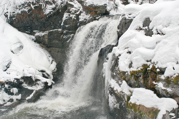 Moose Fall on Crawfish Creek in winter. Photo by Stephen Earl Williams
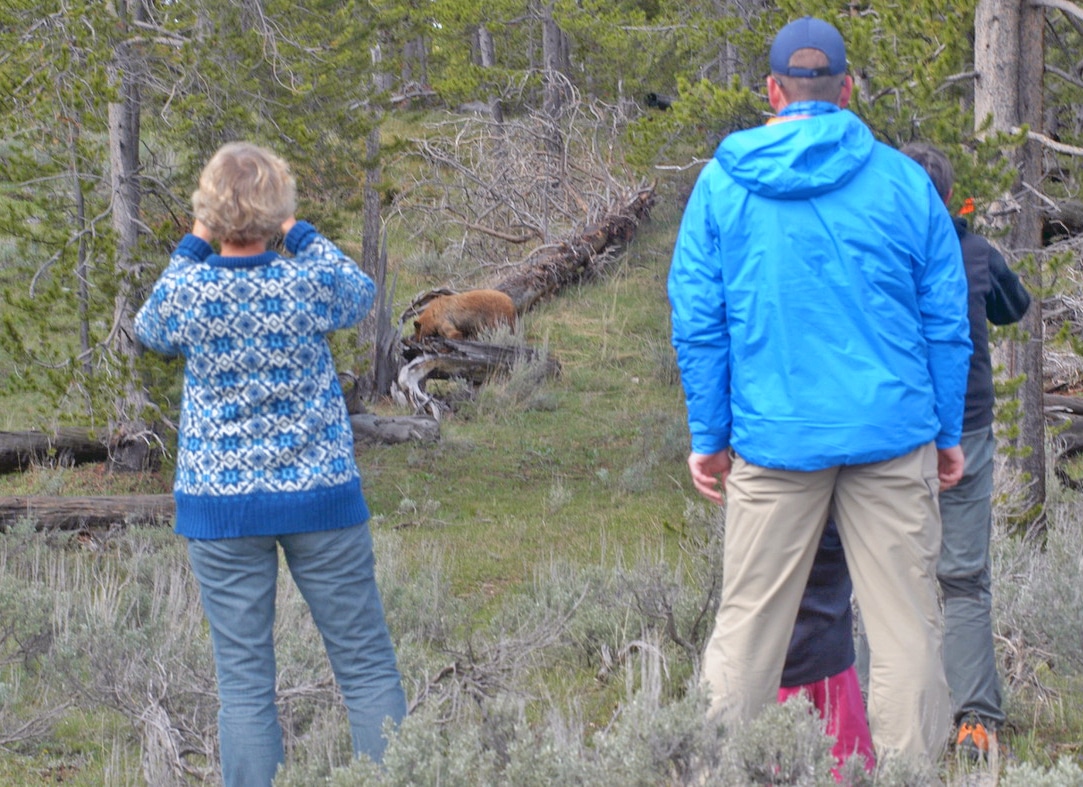 Tourists watch a bear from afar. Photo by Stephen Earl Williams