
 A marshy area near a series of geysers. Courtesy/T. Wallace
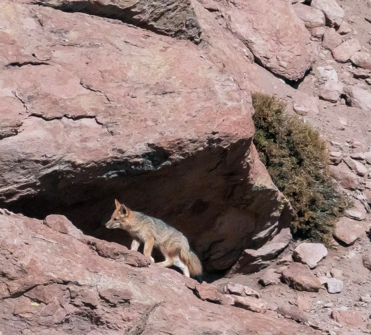 An Atacama fox. Courtesy/T. Wallace
By TERRY WALLACE
Los Alamos
The Atacama Desert: an ecosystem on the edge. The Atacama Desert – usually just referred to as the Atacama – is a narrow strip of land between the high Andes in the east and the Pacific Ocean in the west, the Chile-Peru border in the north and the Chilean Matorral in the south.
The north-south length of the Atacama is about 1500 km and it is 70-120 km wide (east-west), and is often called the driest desert in the world (I am not really sure that is the case, but it is very dry!). The average rainfall in the northern part of the desert is less than a mm, and only 5 mm in the south, and there are several areas that have never recorded any rainfall. There is moisture in the desert, but it is mostly related to marine fog known as the camanchaca.
The desert owes its existent to plate tectonics (isn’t that always the case?); when the Drake Passage between South America and Antarctica “opened” it created a strong north-flowing current call the Humbolt. The current combined with the South Pacific High – a high altitude pressure cell – create a situation where no clouds can form and move eastward on the continent.
Despite the rather stark setting, there is a marvelous ecosystem populated with interesting flora and fauna. The pictures below are some of the animals we saw in the high country on the eastern side of the Atacama. The elevation of this area is is between 3-5,000 m elevation; the bounding high elevation volcanoes have no glaciers even though they can reach elevations in excess of 6,000 m (~20,000’).
The first picture is a marshy area near a series of geysers – so there is some water fed by the high mountains. The herd animals are vicuña a type of camelid. The vicuña wool is considered the softest and warmest in the world, but vicuña cannot be domesticated, so the wool is extreme rare. The second picture is the Atacama fox; the third picture is the Chilean flamingo. Finally, the fourth photo is me along a drainage from the geysers looking at the only vegetation for miles.
It is thought the Atacama Desert is the oldest desert in the world – it probably has experience hyperaridity for at least 3 million years. This long dry period has resulted in many salt flats – enclosed regions where the infrequent moisture drains only to be evaporated leaving behind the dissolved minerals carried down from the high landscape. The largest of these salt flats is the Salar de Atacama – located only a few miles from Volcano Lascar. Salar de Atacama is the world’s largest source of lithium – probably more than 25% of the world’s lithium reserve (this is not really correct – there is lots of lithium trapped in various minerals, but the concentrations are so low that it is not economical to recover).
The Salar de Atacama is considered the world’s single most important lithium resource and the demand for rechargeable batteries has brought huge new facilities to “mine” the salt flats. The fifth figure shows one of these facilities – it is a series of brine ponds that pump water down drill holes dissolving the lithium and then returning the salty water to the surface and emptied into ponds. The ponds evaporate in the dry high climate concentrating the lithium (mostly lithium carbonate). In the figure the pale blue colored ponds are low concentrations of lithium, while the yellow are high concentrations. This cascade process is extremely water intensive.
This is having a tremendous impact on the ecosystem, and over a single decade the water table around Salar appears to have dropped by nearly 100’. Simple calculations show that the evaporation of the ponds is 300 times the rate of recharge. Figures 6 and 7 below show satellite images of the Salar 20 years separated.
When I was in the Atacama every person I talked to was concerned about the lithium mining, but every single one of these people praised the high paying jobs and did not want the lithium mining to stop…this is the definition of ecocide. #huttonproject
 Figure 6: A satellite image of the Salar 20 years before the below image. Courtesy/T. Wallace
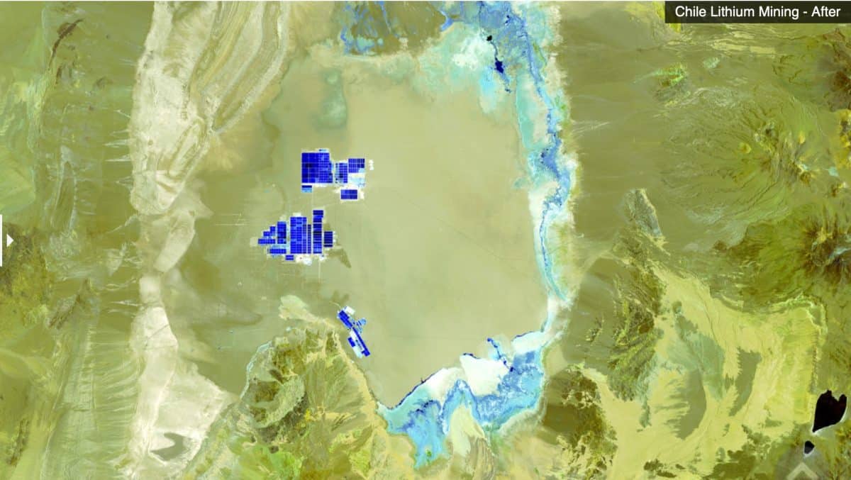 Figure 7: A satellite image of the Salar 20 years after the above image. Courtesy/T. Wallace
 A Chilean flamingo. Courtesy/T. Wallace
 Terry Wallace along a drainage from the geysers looking at the only vegetation for miles. Courtesy/T. Wallace
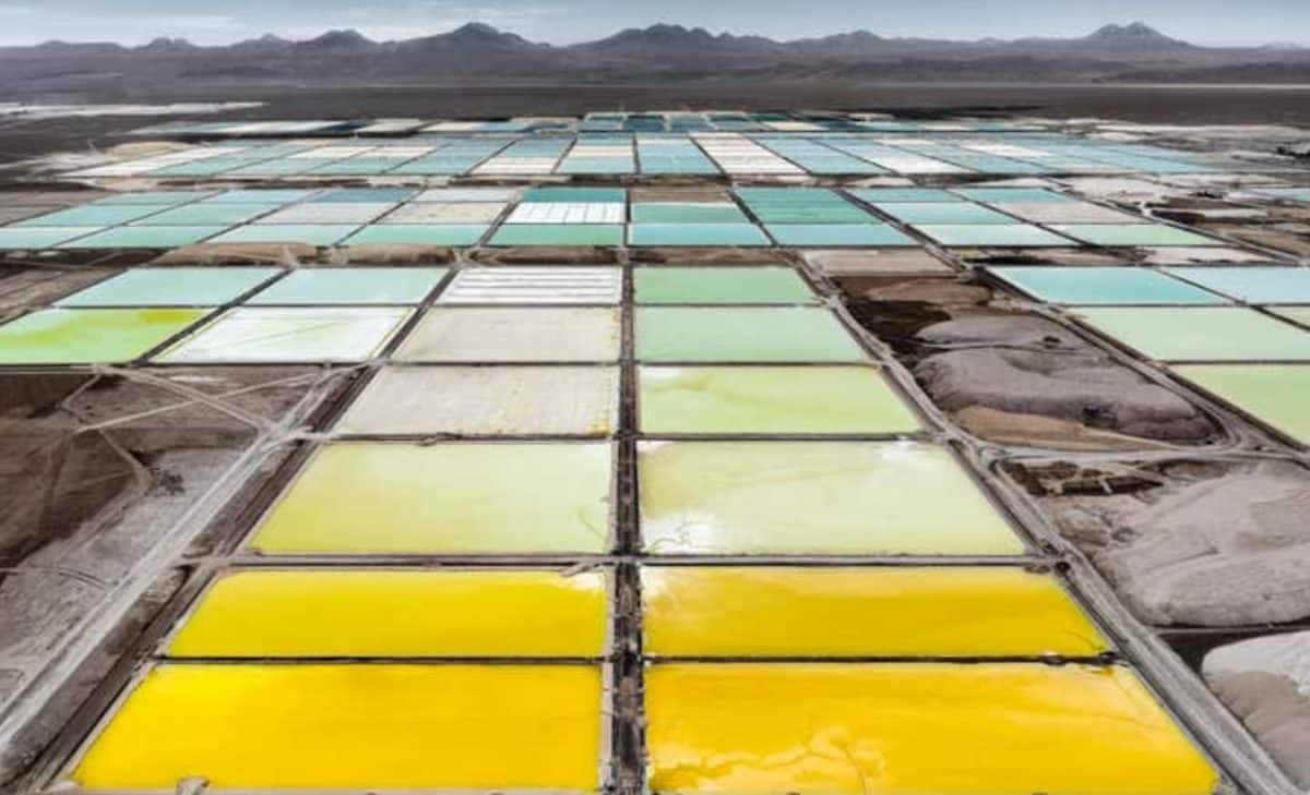 A series of brine ponds that pump water down drill holes dissolving the lithium and then returning the salty water to the surface and emptied into ponds. Courtesy/T. Wallace