
 Lewiston-Clarkson: A viewpoint just out of Lewiston, Idaho on Highway 95 gives visitors a nice view of the cities of Lewiston and part of Clarkson, Wash. The viewpoint is almost 2,000 feet higher in elevation than Lewiston at the river level. Lewiston is seen on the left side of the photo and Clarkson on the right. The two cities and surrounding area are the center of activity and population in the Lewis Clark Valley. Photo by Gary Warren/ladailypost.com
 Confluence: The confluence of the Clearwater River seen on the left in the photo and the larger Snake River seen in the upper and right side of the photo. The confluence of two major rivers is a natural setting for settlement but this settlement actually falls in two states, Idaho on the left and Washington on the right divided by the Snake River. Photo by Gary Warren/ladailypost.com
By GARY WARREN
Photographer
Formerly of Los Alamos
The mountains of the north and central Idaho is the picture that most of us would form when thinking of the state of Idaho. Certainly, that would be an accurate description of those portions of the state.
However, there are other parts of Idaho which differ such as the Lewis Clark Valley on the Idaho and Washington border. While the valley is part of northern Idaho, it is much different than the higher mountainous areas of the northern Idaho.
Lewiston, Idaho sits at the confluence of the Clearwater River and the Snake River at an elevation of a mere 740 feet in elevation. Not only that, Lewiston also has an active seaport, the most inland seaport on the west coast! While the city is 465 miles from the Pacific Ocean, barges are able to make shipments from Lewiston to larger ports on the Pacific coast via the Snake River and the Columbia River.
The Lewis Clark Valley consists of two cities that make up the population hub for this part of Idaho, Lewiston, Idaho. and Clarkston, Wash. When visiting the area in July we stayed in Clarkston but spent most of our time in Lewiston. The boundary between the two cities is the Snake River.
Lewiston is the oldest incorporated community in Idaho. The area became known when the Lewis and Clark Expedition passed through the area in 1805 as they traveled west and again in 1806 when they were traveling back toward to east.
The Nimiipuu people, known as the Nez Perce tribe, inhabited this area for thousands of years. The Nez Perce tribe played a role with the Lewis and Clark Expedition by providing assistance to the Expedition. Today, visitors can visit the Nez Perce National Historical Park near Lewiston and learn more about the people and their history in the area.
The Lewis Clark Valley is known as the Banana Belt of the Northwest. When visualizing the Northwest the term Banana Belt does not seem appropriate but the Lewis Clark Valley is indeed a different environment.
While much of Northern Idaho is covered in snow during winter months the Lewis Clark Valley is basking in the sun much of that time.
The Lewis Clark Valley features an arid, dry climate with only about 12 inches of precipitation per year. Snow will fall in the valley but not much and it usually does not last long. The residents of this part of Idaho enjoy playing golf and other outdoor recreation activities every month of the year.
The major industries in the valley are agriculture, paper and timber products, and light manufacturing. Many of the products produced are shipped by barge to the west coast and beyond.
While the Lewiston elevation is only 740 feet, a portion of the city where much of the residential area lies is about 1400 feet in elevation. We entered the area driving from the north and got our first view of the area at a viewpoint on Highway 95 which was at 2,700 feet in elevation. The area is lowest in the downtown area along the rivers and climbs quickly in elevation as you enter and leave town.
The city of Lewiston is considered the Gateway to Hells Recreation Area. Hells Canyon is the deepest gorge in all of North America at 7,900 feet in depth, over 2,000 feet deeper than the Grand Canyon. However, Hells Canyon is a gorge which is about a mile wide where the Grand Canyon is as wide as 18 miles wide.
The only way to see Hells Canyon is by boat or by air as the terrain is too rugged for normal vehicle travel. We did not have arrangements for a full day tour of the canyon so that will have to wait.
Due to scheduling issues in Denver we were not able to spend nearly enough time in Idaho as we would have liked to have spent. Another trip to the state is necessary to extend our times in several locations that we barely “skimmed the surface” of during this excursion.
Editor’s note: Longtime Los Alamos photographer Gary Warren and his wife Marilyn are traveling around the country, and he shares his photographs, which appear in the “Posts from the Road” series published in the Sunday edition of the Los Alamos Daily Post.
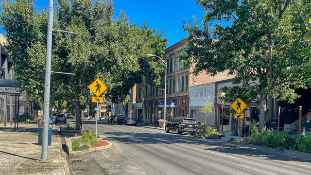 Downtown: Lewiston, Idaho is the larger of the two cities in the valley. Shown is a photo of Main Street where trees line the streets of the historic downtown district of the city. The Lewis-Clark State College is located just blocks from the downtown district. Photo by Gary Warren/ladailypost.com
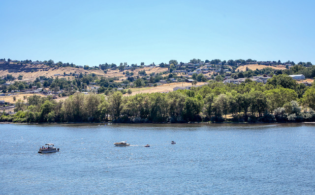 Water Sports: Boating, fishing, and other water sports are naturally popular in the Lewis Clark Valley. The arid and warm climate allow most outdoor recreation activities to take place every month of the year. This view of boaters on the Snake River also shows a portion of Clarkston, Wash. across on the other shore. Photo by Gary Warren/ladailypost.com
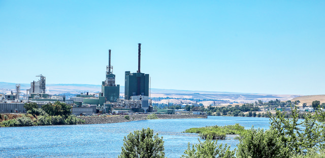 Paper Mill: The Clearwater Paper Mill located on the shores of the Clearwater River is one of the paper mills in Lewiston, Idaho. Paper, timber products and light manufacturing are prominent in the Lewis Clark Valley. Outside of the city, agriculture is seen in many areas of the valley. Photo by Gary Warren/ladailypost.com