
 Viewpoint: A group of hikers stops at a viewpoint near the Canyon Rim Campground to view the river and canyon below. The river is hundreds of feet below the canyon rim, and at one point is over 1,500 feet below the rim. Photo by Gary Warren/ladailypost.com
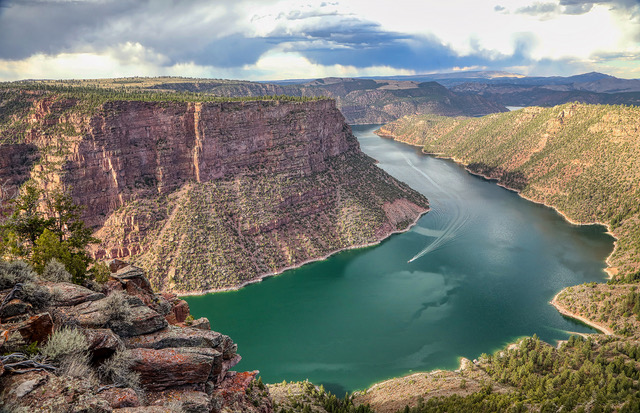
 Flaming Gorge Boaters: Boaters traveling in both directions can be seen as they approach a bend in the Flaming Gorge Reservoir. The photo was made from the Canyon Rim Trail. Boaters continually move up and down through the canyon as they move about in the reservoir. Photo by Gary Warren/ladailypost.com
By GARY WARREN
Photographer
Formerly of Los Alamos
Straddling the Utah and Wyoming border in northeast Utah is the Flaming Gorge National Recreation Area. The main attraction of this massive area is the Flaming Gorge Reservoir, but the area features many other outdoor recreational opportunities.
The 91-mile-long Flaming Gorge Reservoir was formed when the Flaming Gorge Dam was constructed in the 1960s on the Green River. The deep channels of the reservoir twist and turn around mesas and mountains and boast 350 miles of shoreline.
The reservoir features three full-service marinas, which are spaced out beginning near the dam on the south end of the reservoir. The large reservoir offers water sport opportunities from paddleboarding to houseboats.
Boating activities and water skiing are prevalent everywhere on the reservoir, but fishing is also a major draw to the area, as the Flaming Gorge boasts some of the best fishing in the western U.S. Trophy lake trout, along with most other varieties of trout, are the main attraction for fishermen.
In addition to water sports, there are many campgrounds. The Ashley National Forest has many developed campgrounds as well as dispersed camping scattered throughout the recreation area. Backpacking, hiking, and rock climbing are other popular activities in the region.
On the south side of the Flaming Gorge Dam, the Green River has become a popular area for river rafting. The area continues to offer great fishing opportunities as well.
One would expect an area such as Flaming Gorge to be crowded with people, given the numerous outdoor opportunities the area features, but that is not the case. I am sure that during weekends and summer holidays, the area will become filled and crowded, but our experience in mid-August was very pleasant and uncrowded during our days in the area.
The southern portions of the Flaming Gorge Recreation Area feature the more scenic parts of the area. The Uinta Mountains on the eastern side of the reservoir and the canyons formed by the Green River and the Flaming Gorge Reservoir offer visitors many scenic roads to explore and enjoy.
The pine forest within the Ashley National Forest offers great camping opportunities, and with the area averaging about 6,000 feet in elevation, the daytime temperatures were warm and the night temperatures very cool and comfortable. The northern section found around the state border and in Wyoming is more wide-open high desert terrain.
We had never traveled this area of Utah or Wyoming, but found it very scenic and an enjoyable area to explore. While we do not boat or fish, we found plenty of activities and scenic areas to enjoy. I would highly recommend this area, especially for boaters and fishermen, as it would be a paradise for those enthusiasts.
I consider the Flaming Gorge National Recreation Area a hidden gem within the western U.S. The reason it is not more crowded and well-known would be the remote location of the area. Flaming Gorge is easily accessible by vehicle, but it is a very remote area.
Editor’s note: Longtime Los Alamos photographer Gary Warren and his wife Marilyn are traveling around the country, and he shares his photographs, which appear in the “Posts from the Road” series published in the Sunday edition of the Los Alamos Daily Post.
 Flaming Gorge Reservoir: The Flaming Gorge Reservoir was created in 1964 when the Flaming Gorge Dam was completed. Waters from the Green River began to fill the deep canyons and wider open valleys along the route of the river. Today the reservoir is 91 miles long. The rugged Uinta Mountains sit on the eastern side of the reservoir and the pine forest and canyon lands of Ashley National Forest are to the west of the reservoir. Photo by Gary Warren/ladailypost.com
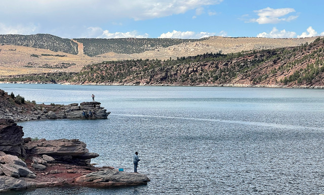 Fishing and Swimming: A fisherman is seen fishing from the shore while a group of swimmers play on the rocks farther up the shoreline. While much of the activities in the area are centered around boating, there are many other activities to enjoy that do not involve boating. Photo by Gary Warren/ladailypost.com
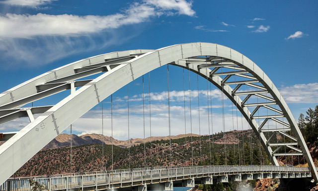 Bridge: The Cart Creek Bridge is located on Utah Highway 191 on the south end of Flaming Gorge Reservoir. The eye-catching structure was constructed in 1962 to provide workers with a route to the dam, which is less than a mile away. The bridge is still used today and offers visitors a chance to stop and admire the single-span suspension bridge. Photo by Gary Warren/ladailypost.com
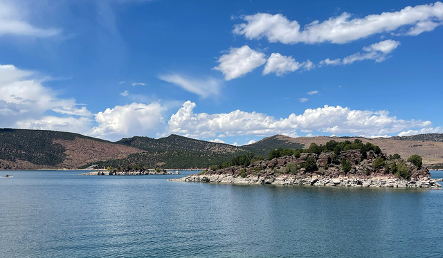 Islands: Two islands can be seen from the Flaming Gorge Dam visitors center on the southern end of the reservoir. There are islands within the reservoir throughout the 91-mile length of Flaming Gorge Canyon. Photo by Gary Warren/ladailypost.com
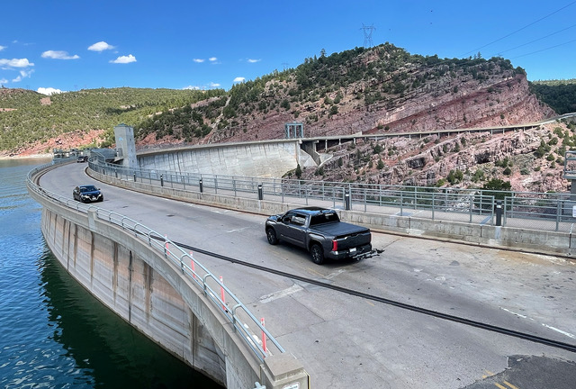 Flaming Gorge Dam: The Flaming Gorge Dam was constructed in the 1960s and completed in 1964. The dam is 502 feet high and 1,285 feet long. Utah Highway 191 travels across the bridge and leads drivers north to I-80 in southern Wyoming. Photo by Gary Warren/ladailypost.com