
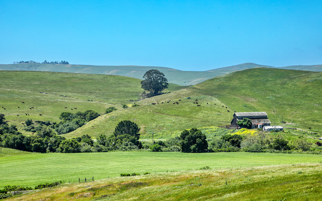
 Hills & Pastures: Lush green hillsides provide pastures for cattle near Cambria, Calif. While the area is a more rural setting with farms and ranches, the coastline and Pacific Coast Highway are just beyond the distant ridge in the photo. Photo by Gary Warren/ladailypost.com
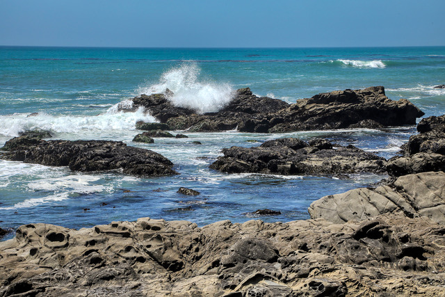 Crashing Wave: A wave crashes against the rocky and rugged shores at Cambria, Calif. This closer view gives viewers an idea of the size and magnitude of the waves as they crash against the central California coastline. Photo by Gary Warren/ladailypost.com
By GARY WARREN
Photographer
Formerly of Los Alamos
After an enjoyable time exploring the coast in Pismo Beach and Morro Bay we moved north a short distance, driving the California Pacific Coast Highway to Cambria, San Simeon, and beyond.
We found the area around Cambria to be very interesting as the beautiful Pacific Ocean shoreline continued to amaze us with spectacular views around every curve in the road. However just to the east were hills and valleys with green pastures and cattle grazing as well as small farms. A few miles inland the hillsides are covered with vineyards and wineries in the Paso Robles area. The ocean vibe quickly shifted to a more rural atmosphere, which seemed to be miles from the ocean. In reality, the ocean air was still apparent and the skies over the ocean were visible even though the waters were hidden from site by the hillsides.
We had to stop at a fruit stand by the highway near Cambria and purchase ripe red strawberries the size of small oranges as well as some fresh blueberries. This added to our case of tangerines and bag of oranges which we bought inland near Bakersfield, Calif. The fresh fruit was beyond anything we taste from the grocery stores at home.
A little farther north Highway 1 took us by San Simeon State Park and then through the small town of San Simeon. Just north of San Simeon Hearst Castle, the home of publishing tycoon William Randolph Hearst, which is visible high on the mountain just east of Highway 1. Just to the west of the highway is the tiny community of Old San Simeon Village, Calif. with a history that goes back over 150 years.
A handful of miles to the north of the Hearst Castle and Old San Simeon Village is the Piedras Blancas Elephant Seal Rookery. This beach is home to thousands of elephant seals and has an amazing story and history itself.
The Hearst Castle and the elephant seal rookery will be featured on upcoming Post From the Road posts.
Moving northward drivers continue along the coastline with areas to stop and enjoy the special views and coastal beauty before reaching the village of Ragged Point, Calif.
The village of Ragged Point is home to Ragged Point Vista along with the Ragged Point Inn and Resort and numerous hiking trails leading to closer views of the magnificent scenery. Ragged Point offers incredible vista views of the ocean from atop the 400 foot high cliff viewpoints and trails. This area is the northern end of San Luis Obispo County where the coastline transitions to the even greater known Big Sur Coast in Monterey County.
The coastline begins to feature higher cliffs which offer fabulous views but are more difficult or impossible to walk along the shore. At Ragged Point visitors can sit and enjoy the “million dollar views” or they can hike and view waterfalls as streams reach the coastline and fall into the ocean beaches below. For the more experienced hikers the Ragged Point Cliffside Trail leads hikers down a steep switchback trail 400 feet in elevation to the shoreline below. The trail also leads hikers up the steep switchbacks for 400 feet to return to the village!
Beyond the area of Ragged Point Highway 1 veers a short way east through the mountains before returning to the coast and the cliffside views farther north. After hugging the coast for several miles, drivers arrive at the small town of Lucia, Calif.
However, two miles north of Lucia Highway 1 is closed due to a landslide resulting from a storm in February 2024. The 6.8-mile section of the highway has been closed since the storm and will be closed until at least the fall of 2025. Road crews are working around the clock to rebuild and stabilize the section of the road destroyed by the storm. While the road was washed out in a short section, the state has closed the 6.8 mile section for safety.
To see “the north side of the washout” will require a detour of over 100 miles from Highway 1 to Highway 101 at Paso Robles, Calif. From Paso Robles we will travel 101 almost 100 miles to Salinas, Calif. and then back west to Monterey, Calif. where we take Highway 1 south to the north end of the closure. Never a dull moment when you are traveling the highways and byways! The closure was well publicized, so we were able to plan accordingly.
There will be more tales of adventure along the central California coast in upcoming Posts From the Road … stay tuned!
Editor’s note: Longtime Los Alamos photographer Gary Warren and his wife Marilyn are traveling around the country, and he shares his photographs, which appear in the “Posts from the Road” series published in the Sunday edition of the Los Alamos Daily Post.
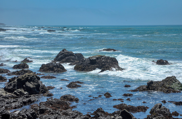 Rocky Shores: While there are sandy beaches all along the coast, there are also many areas of rocky shores along the coast of California. Seen is a rocky area in Cambria, Calif. The towns and villages along the coast have created miles of walkways, trails, and even boardwalks in some areas, which allow visitors to enjoy the magnificent views, wildlife, and nature along the coastline. Photo by Gary Warren/ladailypost.com
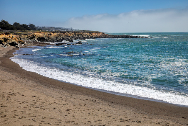 Cambria Coastline: Along with the picturesque cliffs and rocky shores there are many sandy beaches. Shown is a view of a beach just north of Cambria, Calif. The shores of the Pacific Ocean constantly change from rugged and rocky to more calming sandy beach shores all along the central California coast. One constant is the beautiful views of the coast no whether the shores are sandy or rugged. Photo by Gary Warren/ladailypost.com
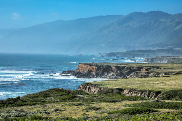 Coastline Beauty: As we navigated our way farther north the coast begins to transition from shores along the roadway to a more mountainous coast in northern San Luis Obispo County. This image illustrates the transition as the San Lucia Mountain Range comes into view. Photo by Gary Warren/ladailypost.com
 Ragged Point: Ragged Point protrudes into the ocean at an elevation of over 400 feet above the shoreline. The viewpoint and trails offer a variety of magnificent views of the ocean, coastline and mountains. The village at Ragged Point is basically a resort, hotel and grounds for visitors to enjoy this section of the coast. Photo by Gary Warren/ladailypost.com
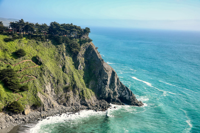 Point Close Up: A closer view of the Ragged Point reveals the strenuous Ragged Point Cliffside Trail (seen on the left in the photo), which allows hikers to take a route to the waters below. Several trails allow hikers to enjoy the views from various viewpoints, while other trails lead to waterfalls in the area. Also visible at the top is a portion of the resort and hotel where visitors can stay and enjoy the area. Photo by Gary Warren/ladailypost.com