
 Peaks and Valleys: When traveling the Chief Joseph Scenic Highway from the southern end out of Cody, Wyo. the hills and valley landscapes are more gentle. Just a few miles farther up the scenic drive into the mountains the views become much more rugged. Photo by Gary Warren/ladailypost.com
 View from the Pass: Dead Indian Pass is the highest point on the Chief Joseph Scenic Highway in Wyoming. Shown is a view of the road as it twists and turns as it drops in elevation when leaving the pass to the north. The pass is 8,071 feet in elevation and offers spectacular views of the Absaroka Mountains and beyond from the scenic viewpoint. Photo by Gary Warren/ladailypost.com
By GARY WARREN
Photographer
Formerly of Los Alamos
Wyoming highways can lead one to many plains and rolling hills but those pathways also lead to some spectacular mountains, canyons and valleys. One of the scenic drives which we drove for the first time this month was the Chief Joseph Scenic Highway.
While this short scenic drive is only 46 miles long, it is not short of beautiful mountain scenery, vistas, and many thrilling switchbacks as the roadway ascends and descends over Dead Indian Pass midway through the drive. Perhaps the most impressive viewpoint is located at the lowest point on the road, Sunlight Bridge where one can view the Clarks Fork Canyon from the walkways on both sides of the bridge. One should allow two hours to drive the scenic road and enjoy the views along the way.
The Chief Joseph Scenic Highway is almost entirely within the Shoshone National Forest and it links Cody, Wyo. to the Beartooth Highway National Scenic Byway and the Northeast entrance to Yellowstone National Park. The roadway travels through the Absaroka Mountains in a northwestern direction.
We traveled the highway beginning at the southern end, which is just outside of Cody, Wyo. The Chief Joseph Scenic Highway which is Wyoming Highway 296 begins with smaller mountains with more gentle slopes before gaining elevation and becoming the rugged mountains that make this route a popular scenic drive.
Once drivers begin climbing in elevation the road becomes a series of switchbacks which offer views around every turn in the road. The highest point on the drive is at Dead Indian Pass which is 8,071 feet in elevation. That is not a high elevation compared to other mountain passes but it is over 3,000 feet higher than the town of Cody so drivers have climbed over 3,000 feet in elevation in a short distance. The pass offers many vistas as well as a distance view of the Beartooth Mountains to the north.
There are numerous mountain and valley viewpoints along this drive but two locations stand out as must see viewpoints; the views from the pass and the Sunlight Bridge over Sunlight Creek which is the best view of Clarks Fort Canyon, an impressive steep and deep canyon which runs for miles on the northern slopes of the Absaroka Mountains.
So who is Chief Joseph? Chief Joseph was a Native American chief of the Nez Perce tribe. Chief Joseph led his people through the northwest U.S. and into Canada as the U.S. Calvary was in pursuit in 1877. They successfully escaped the calvary in this area when they discovered a way to escape into the Clarks Fort Canyon and move ahead of the U.S. Calvary.
Why is the pass on Chief Joseph Scenic Highway named Dead Indian Pass? Before the highway became a scenic route it was referred to as Dead Indian Hill Road. Why such a morbid name? Speculation is the name comes from loss of lives as the Nez Perce tribe during the Nez Perce War in 1877.
Yellowstone National Park is well known for its beautiful views, unique geological features and an abundance of wildlife but the Chief Joseph Scenic Highway sits just outside of Yellowstone’s Northeast entrance and also offers fabulous views as well.
Northwest Wyoming is wildly beautiful and the Chief Joseph Scenic Highway is a great drive to see and enjoy this portion of the state.
Editor’s note: Longtime Los Alamos photographer Gary Warren and his wife Marilyn are traveling around the country, and he shares his photographs, which appear in the “Posts from the Road” series published in the Sunday edition of the Los Alamos Daily Post.
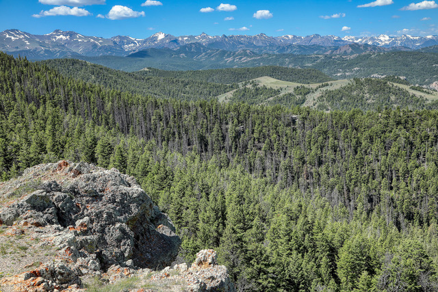 Beartooth Mountains: Viewpoints along the Chief Joseph Scenic Highway offer distance views of the Beartooth Mountains which are to the north. The Beartooth peaks are located along the Wyoming and Montana border. Photo by Gary Warren/ladailypost.com
 Clarks Fork Canyon: A view from the walkway on the Sunlight Bridge on the Chief Joseph Scenic Highway offer stunning views of the Clarks Fork Canyon as it cuts its path through the Absaroka Mountains. The Sunlight Creek can be seen flowing through the canyon 300 feet below the bridge. The Sunlight Bridge is about 6,000 feet in elevation which is 2,000 feet lower than the pass just a short drive from the bridge. Photo by Gary Warren/ladailypost.com
 Absaroka Mountains: A view from the Sunlight Bridge viewpoint shows a portion of the Absaroka Mountains and the Clarks Fork Canyon. The Chief Joseph Scenic Highway lies in the Absaroka Range before intersecting with the Beartooth Highway National Scenic Byway to the north. Photo by Gary Warren/ladailypost.com