
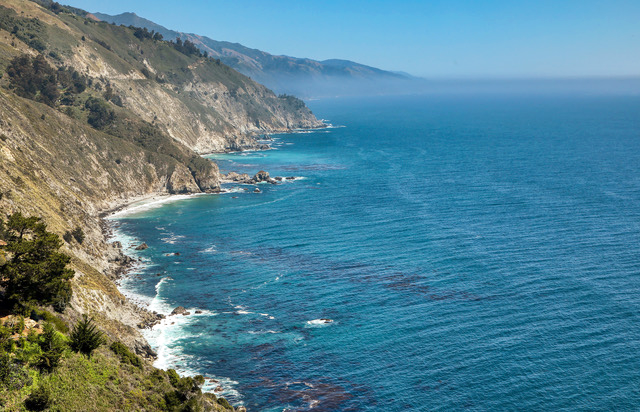
 Big Sur Coastline: Shown is a typical view of the Big Sur coastline from one of many viewpoints along Highway 1. The rugged San Lucia Mountains drop from high peaks to the rocky shores along this section of the California coast. This view is located south of the village of Big Sur, Calif. Photo by Gary Warren/ladailypost.com
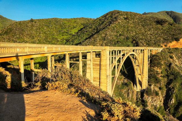
 Coastal Landscape: A view of the coastline, Highway 1, and the iconic Bixby Bridge is seen from a viewpoint about a dozen miles south of Carmel, Calif., and a short distance from the bridge. The late afternoon sunlight gives the scene a warm glow as the sun begins to set. Photo by Gary Warren/ladailypost.com
By GARY WARREN
Photographer
Formerly of Los Alamos
The Central Coast of California is one of the most beautiful places in the country, and some might say one of the most beautiful places in the world.
The San Lucia Mountains frame most of the central coastline as steep ridges and mountains lead from high peaks to the shoreline of the Pacific Ocean.
Cliffs along the rocky shoreline create majestic views of both the landscape and the ocean. Waves crash against the rocks and cliffs up and down the coast. With the ocean to the west, forests of redwood trees, oak, Monterey Cypress, and other trees fill the hillsides and canyons to the east of the road through this section of the coast.
This portion of California’s central coast is known as Big Sur Country. The Big Sur coastline stretches from Monterey, Calif., on the north to San Luis Obispo on the southern end, but the heart of this section stretches from Carmel, Calif., to Ragged Point near San Simeon, Calif., on the southern end.
There are state parks and numerous viewpoints along the route that allow visitors a chance to enjoy the coastal breezes and soak in the majestic landscape. The small village of Big Sur, Calif., is the only townsite along the way between Carmel and Lucia, Calif. The village features small roadside businesses that cater to visitors and travelers in the area.
The Big Sur section consist of only one road, the Pacific Coast Highway, California Highway 1. This is the route that leads drivers around curves and up and down hills from Monterey to San Luis Obispo. Drivers will cross 33 bridges along the way including the famous Bixby Bridge a few miles south of Carmel, Calif. The iconic route is known world wide and is one of the All-American Roads and a National Scenic Byway in the U.S.
This section of Highway 1 through the Big Sur area took 18 years to build and was opened in 1937 from Carmel to San Simeon. While the route is one of the most scenic drives in the world it does have difficulties which have caused numerous closures through the years.
The route is also prone to land slides, mud slides and other destructive forces of nature due to the steep and precarious landscape in the region. When we visited this year a six mile section of the road was closed due to a storm that washed out a section of the highway just north of Lucia, Calif., in February 2024. That portion of the highway will be closed at least until the fall of 2025.
We traveled this section of the coast extensively in May of this year and loved every minute of the journey. There have been a few “Posts from the Road” columns covering our trip, and there will be a few more before we move on from this gorgeous region of California. If you have never seen this portion of the Pacific Coast Highway, it should be on your travel bucket list. If you have visited and driven the highway before, this is a drive that is always worth driving again and again. This is definitely a case where the drive is the destination! We will be back!
Editor’s note: Longtime Los Alamos photographer Gary Warren and his wife Marilyn are traveling around the country, and he shares his photographs, which appear in the “Posts from the Road” series published in the Sunday edition of the Los Alamos Daily Post.
 Bixby Bridge: Located 13 miles south of Carmel, Calif., the Bixby Bridge is one of the most well-known landmarks on the California coast. The bridge, which is 714 feet in length and 280 feet high, spans Rainbow Canyon and the Bixby Creek where it flows into the Pacific Ocean. The bridge was completed in 1932. The bridge has been featured on numerous TV shows and commercials, movies, and even a U.S. postage stamp in 2010. Photo by Gary Warren/ladailypost.com
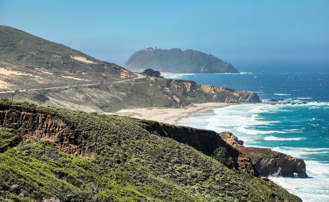
 Rugged Coastline: A view looking south from a Highway 1 viewpoint reveals the rugged and rocky coastline near Julia Pfeiffer Burns State Park in Big Sur country. Photo by Gary Warren/ladailypost.com
 Point Sur: Point Sur State Historic Park: The 361-foot-tall volcanic rock is home to Point Sur Lighthouse, which was built in 1889 to warn ships of the rough waters and rocky shore along the coastline. The lighthouse has been in use continuously since 1889. The Navy operated a Sound Surveillance System at the site during the Cold War, but transferred all but one of the buildings to the California State Parks in 2000. Both the lighthouse and the Naval Facility offer tours of each facility on a limited basis. Photo by Gary Warren/ladailypost.com
 Coastal Fog: Coastal fog is prevalent, especially during warm months, as the cool ocean air meets the warmer temperatures of the land. The fog was light during the time of our visit, but it did appear each day we were on the coast. This scene was captured near Julia Pfeiffer Burns State Park. Photo by Gary Warren/ladailypost.com