
 Beartooth Lake: Ripples from the wind on Beartooth Lake interrupt the reflection of Beartooth Butte, which sits a short distance from the lake. The butte rises 1,500 feet above the lake to an elevation of 10,518 feet above sea level. Photo by Gary Warren/ladailypost.com
 Lakes and Vistas: A viewpoint on the Beartooth Highway reveals stunning alpine vistas including several of the 950 plus lakes in the Beartooth Mountains. Also shown are a few of the switchbacks in the highway as it ascends in elevation. In the distance are the Absaroka Mountains. Photo by Gary Warren/ladailypost.com
By GARY WARREN
Photographer
Formerly of Los Alamos
Called “the most beautiful drive in America” by late CBS travel correspondent Charles Kuralt, the Beartooth Highway National Scenic Byway and one of only 31 “All American Roads” has received this and many other accolades over the years since opening in 1936.
The Beartooth Highway stretches from the Northeast Entrance to Yellowstone National Park near Cooke City, Mont. for 68 miles to Red Lodge, Mont. While both ends of the route are in Montana, almost half of the highway falls within Wyoming.
We recently drove the Chief Joseph Scenic Highway (Wyoming Highway 296) in northwest Wyoming which ends about 18 miles from the west end of the Beartooth Highway which is U.S. Highway 212. See the June 30, 2024, Post From the Road for the story featuring the Chief Joseph Highway.
As we ended the Chief Joseph Scenic Highway, we turned to toward the east to drive the Beartooth Highway. We missed seeing the first few miles from Yellowstone National Park to the intersection of the two Scenic Byways but we had driven that portion of the highway on a previous trip.
Beartooth Lake was our first stop as we began gain altitude on the Beartooth Highway as the nearby Beartooth Butte was reflecting in the lake. There would be numerous opportunities to stop and enjoy the beauty of this byway and the majestic peaks and vistas that surrounds visitors in every direction while traveling the road.
The Beartooth Highway National Scenic Byway crests at Beartooth Pass which is 10,947 feet above sea level and over 5,000 feet higher than our destination of Red Lodge, Mont. on the eastern end of the route. Drivers pass through pine forest to the alpine tundra high above tree line.
Views of the Absaroka Mountains and the Beartooth Mountains area seen along the drive which crosses miles of snowfields as one drives through the high elevation of the alpine tundra. While driving from west to east on the Beartooth Highway the highest point on the route sneaks up on you as you have driven several miles above tree line and the last portion of the ascension is more gradual and suddenly you see the Beartooth Pass, 10,947 feet in elevation signage. A small ski area sits at the pass but it was not open the day we drove the highway.
After reaching the summit from the west drivers begin a seven mile stretch of switchbacks as they descend to lower altitudes on the eastern side of the scenic highway before approaching the valley and the western town of Red Lodge, Mont.
Due to the higher elevations and harsh winters, the Beartooth Scenic Byway is only open a few months of the year. The highway usually opens around Memorial Day and closes for the winter by mid-October.
There is so much to see from this scenic highway. The Beartooth Mountains have more than 950 beautiful lakes to accompany the 20 plus peaks over 12,000 feet in elevation. Another feature of this drive is crossing the 45th parallel which is exactly half way between the North Pole and the equator. Visitors who wish to drive the Beartooth Highway should allow three hours to complete the entire scenic drive.
This is a drive that should be experienced by everyone. As you cross the upper portion of the route you feel as if you are on top of the world. The views seen during this excursion are as special as it gets. Charles Kuralt may have been correct when he called the Beartooth Highway Scenic Byway “the most beautiful drive in America”!
Editor’s note: Longtime Los Alamos photographer Gary Warren and his wife Marilyn are traveling around the country, and he shares his photographs, which appear in the “Posts from the Road” series published in the Sunday edition of the Los Alamos Daily Post.
 High Elevation Tundra: High elevation tundra and a small lake are shown just beyond the Beartooth Pass, which crests at 10,947 feet in elevation. Many of the snowfields in the Beartooth Mountains never completely melt during the summer months. Photo by Gary Warren/ladailypost.com
 Rock Creek Switchbacks: Shown are a small portion of the seven miles of switchbacks in the Beartooth Highway as it descends thousands of feet into Rock Creek Canyon. Photo by Gary Warren/ladailypost.com
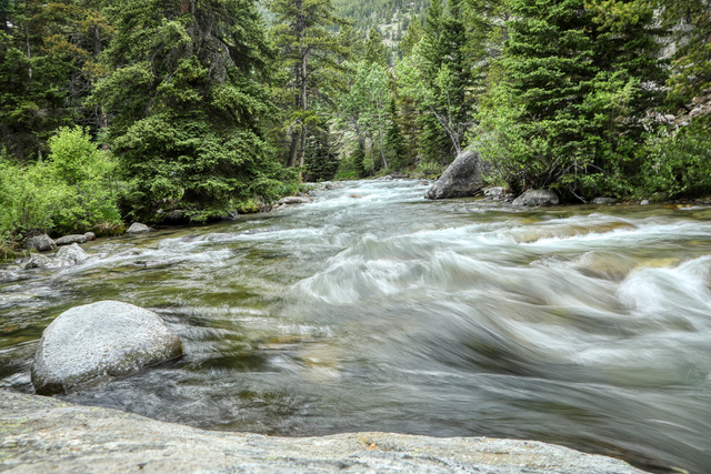 Campground View: We spent the night in one of the nine U.S. Forest Service campgrounds which are located along the Beartooth Highway. Shown is Rock Creek which runs through the campground near our campsite. Photo by Gary Warren/ladailypost.com