
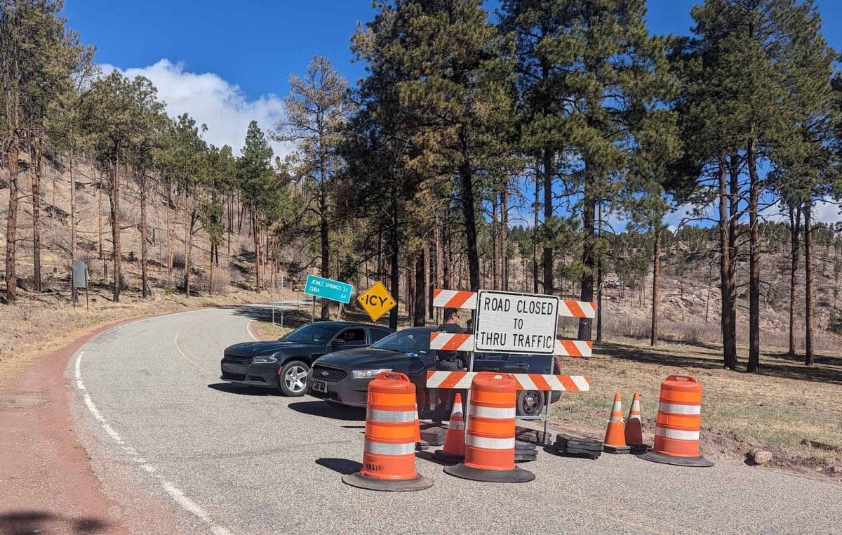
N.M. 4 is will be reopen to traffic starting at noon today. Pictured here is N.M. 4 at mile marker 30 and mile marker 50, where it intersects with West Jemez (back gate), which was closed due to the Cerro Pelado Fire burning in the Jemez Mountains. Courtesy/LANL
USDA News:
N.M. 4 will open to local traffic effective noon today, the U.S. Department of Agriculture announced this morning. Motorists should drive slowly along the highway with headlights on. Fire equipment and firefighters will travel along N.M. 4 and accessing the fire, especially at intersections with Forest Service Road 10 and Forest Service Road 280. If heavy traffic impedes firefighting efforts and endangers firefighter safety, NM 4 could be closed again.
A public meeting about the Cerro Pelado fire will be 5:30-6:30 p.m. today at the Los Alamos High School’s Griffith Gym, 1300 Diamond Drive. Members of the Southern Area Red Team and agency representatives will discuss and answer questions about current progress and planned activities for the fire. The meeting will be available virtually via the Cerro Pelado Facebook page and Zoom: https://us06web.zoom.us/j/
The Cerro Pelado Fire, 7 miles east of Jemez Springs, started on Friday, April 22, during an epic wind event. The cause of the fire is under investigation. It is burning in ponderosa pine and mixed conifer trees and brush. The east part of the fire is burning in the fire footprint from the 2011 Las Conchas Fire. The current fire footprint includes forest units that have previously been treated to reduce fire hazard. Three homes were lost in the fire.
Acreage: 6119 Containment: 5 percent
Personnel and Equipment: 360 total personnel; 16 engines, 1 Type 1 hand crew, 6 Type 2 hand crews, 3 Type 2 initial attack crews, 3 helicopters, 2 dozers, 1 rapid medical extraction unit and 4 water tenders.
Yesterday: Firefighters mopped up hotspots along firelines on the north side of the fire by the Sierra de Los Pinos and Cochiti Mesa communities. They also started to mop up on the southwest side of the fire where they had conducted strategic firing operations. On the southeast side of the fire, firefighters started a tactical firing operation along the Forest Road 270 system. They also used bulldozers to construct fireline in this area. Winds were too gusty for helicopters to fly, but firefighters monitored the fire from fixed wing aircraft. They observed very little smoke on the two spot fires on the east side. Large logs continued to burn in the old Los Conchas footprint.
Today: Firefighters are taking every opportunity to prepare for Friday’s wind event. In the Sierra de los Pinos community, firefighters continue to improve structure protection. They will improve and hold lines on the northwest side of the fire working to the southeast to provide containment. Firefighters will mop along the western and southern portion of the fire. They will also start chipping operations on the west side of the fire to reduce burnable vegetation. Firefighters will use bulldozers to construct fireline near Paliza Canyon on the east side of the fire. They will also install water lines for structure protection on the east side of the fire adjacent to the two spot fires. Helicopters and air tankers will monitor fire behavior in the Los Conchas Fire footprint for hotspots.
Weather and Fire Behavior: Above-normal temperatures will combine with dry, southwest winds to create elevated fire weather conditions today. High temperatures will be in the mid 60s to low 70s. Winds will be southwest, mostly 10-12 mph with 18-23 mph gusts.
Friday will bring critical fire weather across the region. A red flag warning will be in effect from 9 am to 9 pm. West-southwest winds will strengthen ahead of a dry cold front. As the front approaches just after noon on Friday, strong and gusty winds will turn from west-southwest to northwest with gusts of up to 40 mph.
On the north side of the fire low relative humidity and high winds will increase fire intensity in hotspots from recent tactical firing operations. Areas that have been quiet at the northeast section of the fire at the head of Paliza Canyon may become active. The east side of the fire in the Las Conchas fire footprint will continue to actively burn and move to the east. Large pieces of logs and stumps in recently burned areas off of the 270 road system will continue to burn. Wind may align with topography resulting in active fire behavior in this area, creating higher potential for spotting across handlines in recently burned areas.
Evacuations, Shelter Areas: The Sandoval County Fire Department and Emergency Management will provide updated information on evacuations, as needed. Evacuations will be downgraded to “set” for the Sierra de Los Pinos and Cochiti Mesa communities at noon today. Returning residents should remain in “set” mode, meaning being ready to leave on moment’s notice. If conditions change and the fire threatens communities again, these areas could return to “go”.
Air quality: Information on air quality is at New Mexico Department of Health Environmental Public Health Tracking, https://nmtracking.org./fire. An interactive smoke map at https://fire.airnow.gov/ allows you to zoom into your area to see the latest smoke conditions.
The Santa Fe National Forest issued a closure order restricting public access to the area around the fire. Specifically, all Forest Service lands within an area roughly defined by NM Highway 4 on the west, Valles Caldera National Preserve on the north, Bandelier National Monument on the east, and Zia Pueblo and Santo Domingo Pueblo on the south are closed to the public. Order Number 10-506. https://www.fs.usda.gov/
Fire Restrictions: Stage II Fire Restrictions are in effect for the Santa Fe National Forest, which prohibits building, maintaining, attending or using a fire, campfire or stove including charcoal and briquettes. Smoking is also prohibited except within an enclosed vehicle or building, a developed recreation site or while stopped in an area at least 3 feet in diameter that is cleared of flammable material. For other activities prohibited under Stage II Fire Restrictions, see https://www.fs.usda.gov/
Also, due to ongoing fire threats, Sandoval County will not issue burn permits.
Temporary Flight Restriction: There is a flight restriction on the area over the fire (10 nautical miles southwest of Los Alamos, NOTAM 2/2366). https://tfr.faa.gov/save_