
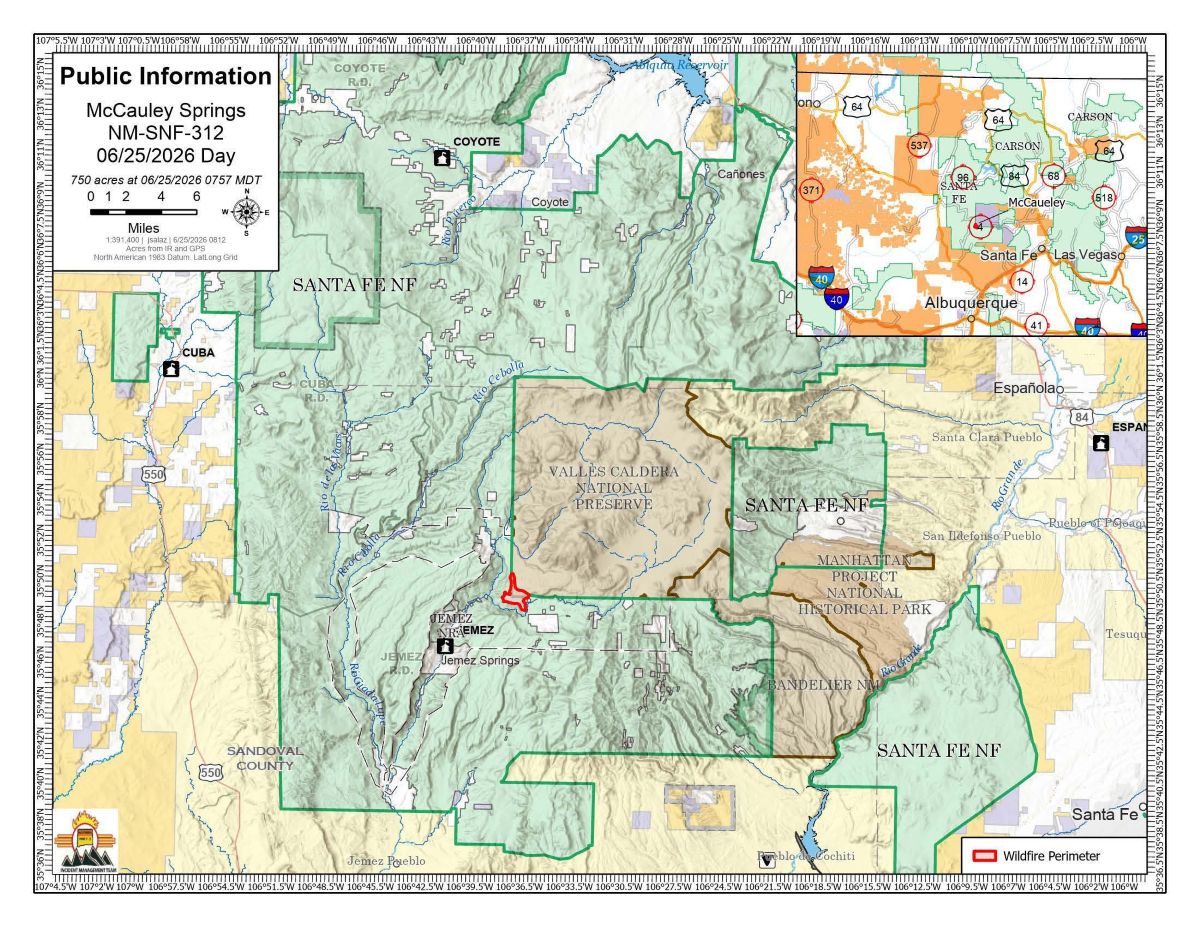
 Map depicting McCauley Springs Fire perimeter in the Jemez. Courtesy/USFS
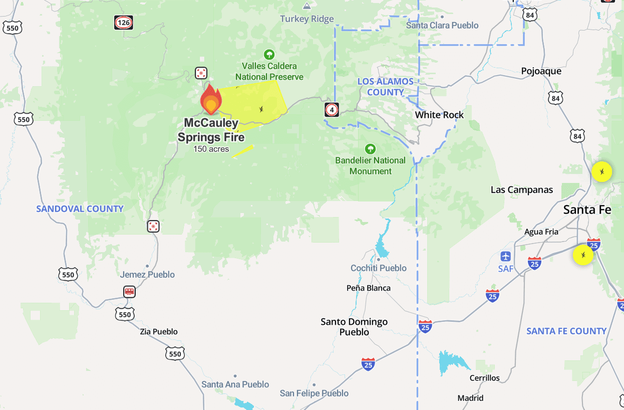 Map depicting McCauley Springs Fire perimeter in the Jemez. Courtesy/USFS
FOREST SERVICE Update:
The Northern New Mexico Type 3 Incident Management Team, Incident Commander Luke McLarty, assumed command of the McCauley Springs Fire on Wednesday evening.
A Complex Incident Management Team has been ordered and will be arriving today. Both teams will communicate and work closely to ensure a smooth transfer of command.
The current incident management team wants to thank the evacuees and community for following evacuation notifications and getting out expediently to allow firefighters to do their jobs.
Acres:
- 327
Start Date:
- June 24, 2026
Location:
- Jemez Ranger District, east of Battleship Rock
Fuels:
- Timber
Containment:
- 0%
Cause:
- Undetermined
Operations:
- Throughout the day Wednesday as weather conditions allowed, Large Air Tankers (LATs) dropped retardant to help slow the fire’s spread. Three type one helicopters conducted water drops, aiding firefighters on the ground. The Sacramento and Blue Ridge Interagency Hotshot Crews (IHCs) arrived Wednesday evening to bolster resources, joining the Santa Fe and Wolf Creek IHCs, numerous local and federal engines and two dozers. Overnight, crews conducted multiple strategic firing operations along Highway 4 west towards Banco Bonito. They also stitched together direct and indirect handline, dozer line, and the Jemez Falls Campground road system and burned out small indirect pockets. A structure protection group consisting of multiple local engines remained in the Sierra de los Pinos area overnight, implementing structure protection measures. Overnight, temperatures cooled and winds subsided, working in firefighters favor. The fire is under a full suppression strategy and today crews will continue implementing mixed direct and indirect suppression tactics. Crews will hold and secure the lines that were burned out last night. Line will be constructed directly along the fire’s edge where it is safe to do so. Heavy equipment operators will continue constructing dozer line. Firefighters will scout along the northern flank for direct opportunities but will assess indirect options as well.
Safety:
- The primary objective for the McCauley Springs Fire is firefighter and public safety. A Temporary Flight Restriction (TFR) is in place to keep the area clear for responding aircraft. No drones or aircraft are allowed to fly in the area. Flying will force air resources to be grounded immediately. If you fly, they can’t.
Weather:
- Humidity is trending up compared to the past few days, bringing good recovery overnight. Chances for wetting storms will trend up Thursday and Friday as well, but thunderstorms also bring the potential for strong and erratic wind gusts. Southwest winds will trend up this weekend, while humidity trends down, bringing a moderate to high probability for critical fire weather conditions both Saturday and Sunday.
Smoke:
- Smoke is visible from Albuquerque, U.S. 550, Jemez Springs, and surrounding communities and may impact areas of N.M. 4. View an interactive smoke map at https://fire.airnow.gov/. Learn about smoke impacts at https://nmtracking.org/environment/air/FireAndSmoke.html.
Closures:
- A Forest Closure Order will go into effect today and can be found on the Forest website at https://www.fs.usda.gov/r03/santafe/alerts.
Coordinating with Sandoval County, evacuations are in place:
- Go status (evacuate) – Sierra de los Pinos, and Jemez Falls Campground.
- Evacuation centers – for residents are located at Jemez Mountain Baptist Church in La Cueva, NM and the Jemez Valley Senior Center at 8154 N.M. 4.
- Ready status – Los Alamos County.
- Closures – N.M. 4 from Mile Marker 27-40, Battleship Rock Campground, Jemez Falls Campground, Redondo Campground, Trail #137.
Fire Information:
- 505.273.6432 / facebook.com/santafeNF/ https://x.com/SantafeNF / 2026.mccauleysprings@firenet.gov / nmfireinfo.com.