
 LAPS School Board voted to adopt Plan D as the new voting redistricting boundaries for Los Alamos County. Courtesy/LAPS
LAPS News:
During its Nov. 8 meeting, members of the Los Alamos Public Schools (LAPS) Board voted 4-1 to adopt Plan D as the new voting redistricting boundaries for Los Alamos County.
Michael Sharp of Research & Polling, Inc. had presented the board with five options, which were then narrowed down to three.
Each of the three options included one elementary school represented in each district. Plan D was deemed the most equitably distributed.
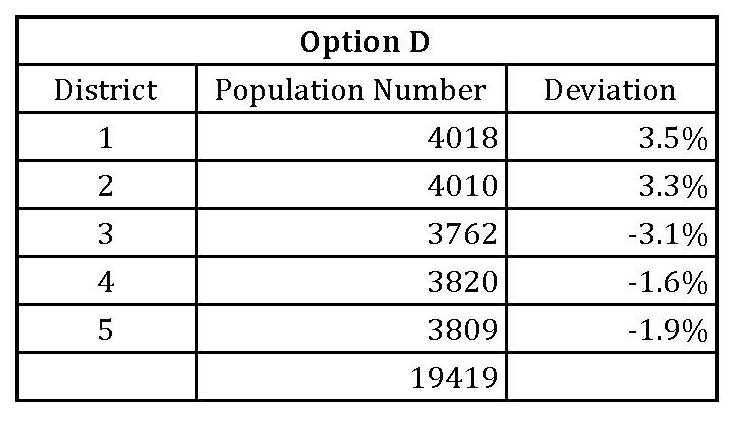 Sharp presented the LAPS board with five options. Courtesy/LAPS
Here is a description of the boundaries represented in Plan D which have been provided by Research & Polling, Inc.:
District 1
Beginning at the intersection of the western Los Alamos County line and State Highway 4, easterly along State Highway 4 to State Highway 501, northerly along State Highway 501 to West Jemez Road, easterly along West Jemez Road to East Jemez Road, westerly along East Jemez Road to Diamond Drive, northerly along Diamond Drive to Canyon Road, easterly along Canyon Road to Central Avenue, easterly along Central Avenue to 9th Street, northerly along 9th Street to Graduation Canyon, easterly along Graduation Canyon to Pueblo Canyon, easterly along Pueblo Canyon to Los Alamos County line, southerly along Los Alamos County line to N.M. 4, westerly along N.M. 4 to Sherwood Blvd., southerly along Sherwood Blvd. to Grand Canyon Drive, easterly along Grand Canyon Drive to Rover Blvd., southerly along Rover Blvd. to Kimberly Lane, southerly along Kimberly Lane to gully, southerly along gully to Pajarito Canyon, easterly along Pajarito Canyon to the Los Alamos County line, southerly, westerly and northerly along the Los Alamos County line to the point of beginning.
Precincts: 1, 7 (part south of Grand Canyon Dr), 8, 9, 10
District 2
Beginning at the intersection of State Highway 4 and Sherwood Blvd., easterly along N.M. 4 to the Los Alamos County line, easterly and southerly along the Los Alamos County line to Pajarito Canyon, westerly along Pajarito Canyon to gully, northerly along gully to Kimberly Lane, northerly along Kimberly Lane to Rover Blvd., northerly along Rover Blvd. to Grand Canyon Drive, westerly along Grand Canyon Drive to Sherwood Blvd., northerly along Sherwood Blvd. to the point of beginning.
Precincts: 2, 3, 4, 5, 6, 7 (part north of Grand Canyon Drive)
 The map above shows District 1 and 2 of the newly approved Plan D, new voting redistricting boundaries for Los Alamos County. Courtesy/LAPS
District 3
Beginning at the intersection of the northern Los Alamos County line and Agua Piedra Canyon, easterly along Agua Piedra Canyon to unnamed local road, southerly along unnamed local road to Upper Guaje Road, southerly along Upper Guaje Road to Rendija Canyon, easterly along Rendija Canyon to stream/river, southerly along stream/river to Barranca Road, westerly along Barranca Road to drainage, southerly along drainage to Bayo Canyon, westerly along Bayo Canyon to San Ildefonso Road, southerly along San Ildefonso Road to golf course maintenance road, westerly along golf course maintenance road to East Fork, southerly along East Fork to Walnut Canyon, southerly along Walnut Canyon to Pueblo Canyon, easterly along Pueblo Canyon to Graduation Canyon, westerly along Graduation Canyon to 9th Street, southerly along 9th Street to Central Avenue, westerly along Central Avenue to Canyon Road, westerly along Canyon Road to high school access road, northerly along high school access road to Acid Canyon, easterly along Acid Canyon to Pueblo Canyon, westerly along Pueblo Canyon to School Canyon, northerly along School Canyon to stream/river, westerly along stream/river to ridge line, westerly along ridge line to stream/river, southerly along stream/river to ridge line, southerly along ridge line to trail, southerly along trail to Quemazon Trail, westerly along Quemazon Trail to unnamed local road, westerly along unnamed local road to the Los Alamos County line, northerly and easterly along the Los Alamos County line to the point of beginning.
Precincts: 15 (part west of Barranca Road and drainage west of El Viento Street down to Bayo Canyon), 16, 17, 23
District 4
Beginning at the intersection of the eastern Los Alamos County line and Pueblo Canyon, westerly along Pueblo Canyon to Walnut Canyon, northerly along Walnut Canyon to East Fork, northerly along East Fork to golf course maintenance road, easterly along golf course maintenance road to San Ildefonso Road, northerly along San Ildefonso Road to Bayo Canyon, easterly along Bayo Canyon to drainage, northerly along drainage to Barranca Road, easterly along Barranca Road to stream/river, northerly along stream/river to Rendija Canyon, westerly along Rendija Canyon to Upper Guaje Road, northerly along Upper Guaje Road unnamed local road, northerly along unnamed local road to Agua Piedra Canyon, westerly along Agua Piedra Canyon to the Los Alamos County line, easterly and southerly along the Los Alamos County line to the point of beginning.
Precincts: 11, 12, 13, 14, 15 (part east of Barranca Road and drainage west of El Viento Street down to Bayo Canyon)
District 5
Beginning at the intersection of the western Los Alamos County line and State Hwy 4, northerly along the Los Alamos County line to unnamed local road, easterly along unnamed local road to Quemazon Trail, easterly along Quemazon Trail to trail, northerly along trail to ridge line, northerly along ridge line to stream/river, northerly along stream/river to ridge line, easterly along ridge line to stream/river, easterly along stream/river to School Canyon, southerly along School Canyon to Pueblo Canyon, easterly along Pueblo Canyon to Acid Canyon, westerly along Acid Canyon to high school access road, southerly along high school access road to Canyon Road, westerly along Canyon Road to Diamond Drive, southerly along Diamond Drive to East Jemez Road, easterly along East Jemez Road to West Jemez Road, westerly along West Jemez Road to State Highway 501, westerly along State Highway 501 to State Highway 4, westerly along State Highway 4 to the point of beginning.
Precincts: 18, 19, 20, 21, 22
 The map above shows Districts 1,3,4, and 5 of the newly approved Plan D, new voting redistricting boundaries for Los Alamos County. Courtesy/LAPS