
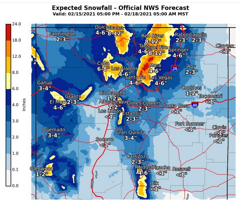
 The NWS forecasts 4-6 inches of snowfall through Wednesday in Los Alamos. Courtesy/NWS
NWS News:
The third in a series of storm systems will impact the region tonight through Wednesday, bringing the threat for hazardous winter travel due to snow and freezing fog as well as cold temperatures and wind chills.
The best chances for snow tonight will be across the northwestern quadrant of the state, expanding to include a large portion of western and central New Mexico on Tuesday.
For Tuesday night through Wednesday, the main focus will be across the northern mountains into the northeast and east central plains. A reinforcing punch of cold air will accompany this system with high temperatures Wednesday 15-30 degrees below normal.
Widespread single digit wind chills are expected Tuesday night.
Key Impacts
- Hazardous travel conditions due to icy, snow-packed road conditions. Secondary roads with lingering snow from the previous storm system will likely become more difficult.
- Freezing fog will reduce visibility and create slick roads, producing hazardous travel. This risk will be favored Tuesday night across the northwest and west central highlands and eastern plains.
- Very cold temperatures and wind chills will return, especially Tuesday night and Wednesday. This will increase the risk for frostbite and hypothermia if protective actions are not taken.
Timing
The worst travel impacts across western and central New Mexico will likely be felt tonight into Tuesday, then focused across the northern mountains into the northeast and east central plains Tuesday night and Wednesday.