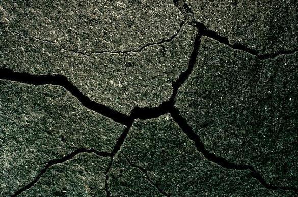
 Cracks in cooling lava. Courtesy Photo
 Amateur Naturalist: The Shape of Acid Canyon
By ROBERT DRYJA
Acid Canyon is approximately 0.8 of a mile in length. The north side of Acid Canyon is relatively steep for its entire length. It has a nearly vertical drop of twenty feet at its start. The drop increases to nearly 200 feet at its end where it merges with Pueblo Canyon.
The south side follows a different pattern. The slope leading to the canyon bottom is relatively gentle for the initial half mile. It is an easy hike down the south slope to the bottom. Two bridges cross the streambed along this section. The visual contrast is dramatic after crossing either bridge. A person now is looking up the steep north side compared to the gently sloping south side. However the south side changes to an increasingly steeper slope downstream, becoming similar to the northern side. The increasing steepness begins as the canyon passes by the Nature Center for the final 0.3 mile to Pueblo Canyon.
Why are the slopes of the north and south sides so different at the start? The volcanic formation of the Pajarito Plateau provides a clue. A deep and broad lava layer from the Valles Caldera eruptions would have started cooling at its surface. The cooling surface of the rock would have contracted sooner compared to deeper down where heat was still trapped. The surface contraction resulted in cracks being created. These surface cracks would have extended downward as the lava continued to cool and contract. A pattern of irregularly shaped, growing rectangular cracks were the result.
Erosion over the eons resulted in some cracks becoming wider, deeper and merging together.
The canyon in effect is one large crack that is the result of the erosion and merging of many smaller cracks. The present day vertical walls of the canyon once had been the sides of cracks.
Today we can see the start of cracks at the top of the canyon walls on the north side. The cracks are distinctly wider and form an irregular line. The freezing/thawing of water is breaking the rock at the bottom of the cracks, making them deeper and wider. Water also is washing away the resulting broken rock. Columns of rock that presently form the canyon side will eventually erode or topple over into the canyon.
The south side of the canyon does not follow this pattern of vertical columns for its first half mile. The rock in this area may have been less tightly fused together. It therefore more easily broke into smaller pieces as part of the cooling, freezing/thawing, and eroding processes. A gentle slope is the result.
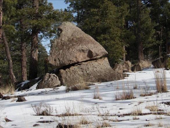
Cracks can develop horizontally as well as vertically. A horizontal crack can develop if there is enough of a slope so that water can move sideways into a crack. The result may be an eroded cap on the top of a column. An example of a cap rock can be seen along the Ranch School trail.
 Growing vertical cracks are creating rock columns along the top of the north wall of the canyon. Photo by Robert Dryja
 Vertical canyon walls are a result of the eroding away of a field of vertical columns of cooled lava. Photo by Robert Dryja
 A vertical column is slowly toppling away from the Acid Canyon side. Photo by Robert Dryja
 A cap rock is pointed as a result of downward erosion while its base is a result of sideways erosion. Photo by Robert Dryja
