
 Picture 1: There are three sections to the Ranch School trail. The bottom section (1) is built into a canyon wall. The middle section (2) crosses relatively level land with dispersed woodlands. The upper section (3) passes through forested land next to the Acid Canyon creek. It merges with Pueblo Canyon. Photo by Robert Dryja
 By Robert Dryja
Los Alamos
The PEEC Nature Center has two hiking trails adjacent to it. The Acid Canyon trail forms a loop into the upper stream section of Acid Canyon. The Ranch School trail forms a single path into the downstream section. Both trails have a common starting point.
The Ranch School trail offers three perspectives. First, one section descends down a canyon wall side and is interesting from a historical perspective. Second, two other sections have differing plant ecology. Third, all three sections together reflect the varying geology that shapes the canyon into which the Ranch School trail descends. There is an approximate 280-foot descent as it goes from its starting point by the Aquatic Center to where it connects with Pueblo Canyon.
The Ranch School was created in 1917 for well-to-do boys coming from the eastern United States. A part of its educational philosophy involved college prep schoolwork.
Another part focused on physical fitness. The boys were expected to become physically fit through regular daily exercises and lifestyle. Building hiking trails was a way to be outdoors while becoming physically fit. Trail building involved cutting canyon walls and making stone steps. It also included laying rocks to make level walking paths, (see pictures 2 and 3). The Ranch School trail could have been made through relatively level areas. It did not need to start at a steep canyon wall side. It could have followed the bottom of Acid Canyon rather than along the side of a steep slope. Instead, the boys cut down through a steep canyon wall for the start of the trail. They finished by building the trail along the sloping side of a canyon side.
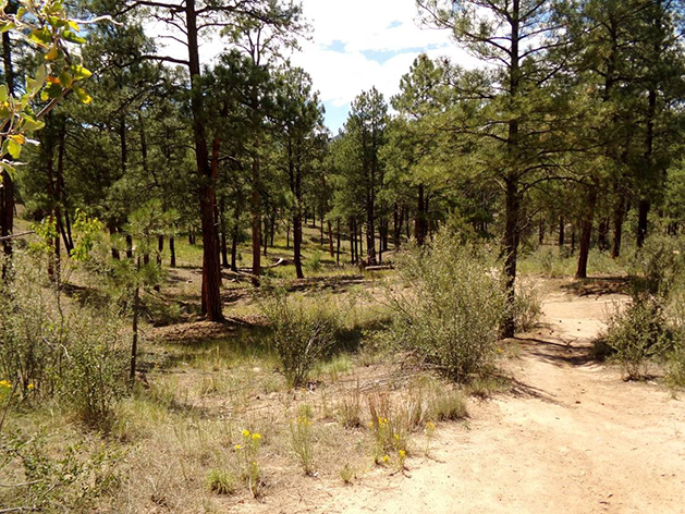
The Ranch School trail crosses a relatively level area mid-way between its starting and finishing sections as it continues to Acid Canyon, (see picture 4). This area is exposed directly to sunlight throughout during the day. It therefore becomes dryer. Trees and shrubs do not grow as well as a result. Acid canyon in contrast has a north facing side. It is shielded from sunlight coming from the south for part of the day. Moisture remains and trees and shrubs now grow more profusely.
A different kind of level trail occurs in Acid Canyon. The trail is built along, rather than up/down, the slope of the north facing canyon side. The canyon side slopes upward on one side of the trail while it slopes downward on the other side. The trail passes through the heavily forested section of the canyon as it slowly descends to the bottom of Acid Canyon, (see picture 5). The Ranch School trail eventually merges with Pueblo Canyon. It then is adjacent to an intermittent stream that flows along Acid Canyon as it approaches Pueblo Canyon, (see picture 6).
The south facing side of Acid Canyon is exposed to more sunlight compared to the north facing side. Like the level area, the south facing wall is dryer and is less forested. The Ranch School trail could have passed along this side but the adjacent landscape would not have been as interesting while hiking. The South Pueblo Bench trail now exists on this side.
The Ranch School trail becomes the Pueblo Canyon trail as it continues along Pueblo Canyon. There is another steep trail where Pueblo Canyon widens as it approaches the Rio Grande River.The Camp Hamilton trail is located in this area and ascends 600 feet. The school boys built it with switch backs the same as Ranch School trail.
 Picture 2: The trail has level pathways built in sections going down the canyon side. Photo by Robert Dryja
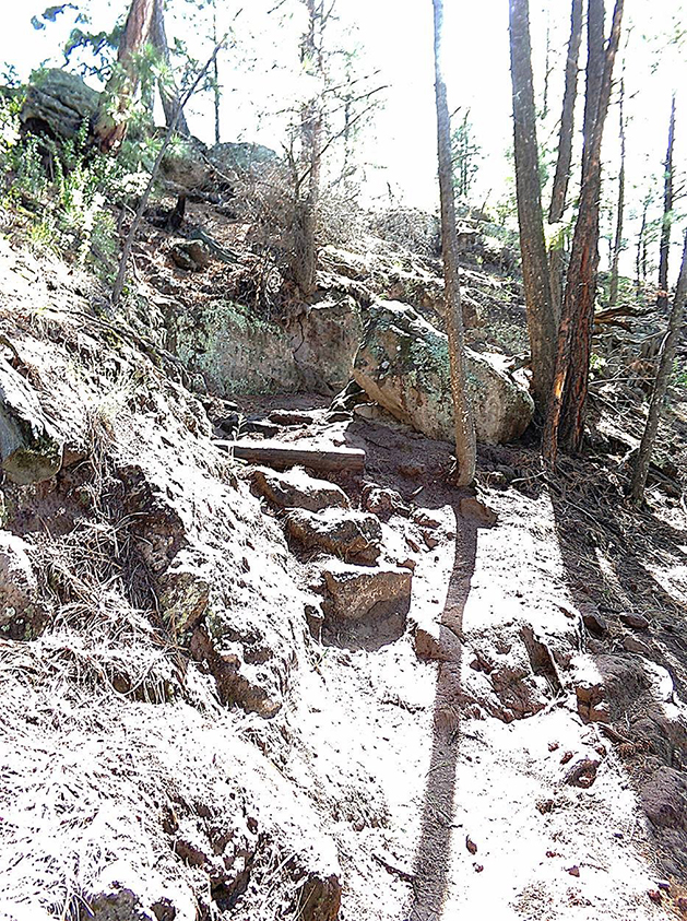 Picture 3: The trail also has stone steps built in steeper canyon wall sections. Photo by Robert Dryja
 Picture 4: A relatively level and open woodlands starts at the bottom of the canyon wall. It continues to the steeper slopes of Acid Canyon where the steam flows. Photo by Robert Dryja