
 By ROBERT DRYJA
Amateur Naturalist
Los Alamos
The Los Alamos Ranch School had an educational philosophy that was a blend of academic learning, physical fitness and community service. The building and maintaining of trails provided a way of achieving physical fitness and community service together.
Trail construction included the cutting of pathways along canyon sides and the placement of chiseled blocks of stone as support walls. Some of the blocks could weigh in the range of 100 pounds. The support walls could be up to 20 feet tall. The walkway between a canyon side and a support wall could be a space up to three feet wide that was filled with rock and soil.
It was possible to design a trail to follow gentle slopes from a mesa top to a canyon bottom. However, a more interesting and challenging trail could be created if a trail was built on a canyon side with switchbacks leading from top to bottom. The Ranch School trail into Acid Canyon is an example of this. It starts with two switchbacks that descend approximately 80 feet to the canyon bottom. A small bridge crosses an intermittent stream at the bottom. The trail continues across a level area before descending again down a canyon side to the bottom of Acid Canyon. This involves a single switch back descending approximately 40 feet. The trail thereafter leads to Pueblo Canyon.
The Ranch School trail is approximately 0.5 mile long from its trailhead to Pueblo Canyon. Pueblo Canyon goes from west to east for 3.3 miles where it opens out near the Rio Grande River. The Camp Hamilton trail is located at this eastern end. The Camp Hamilton trail is about 0.8 mile long, ascending to the easternmost tip of Los Alamos mesa. The Camp Hamilton trail initially is on gentle slopes at the bottom of Pueblo canyon. It then becomes a set of switchbacks as it approaches the top of Los Alamos mesa. There is about 300 feet of elevation change along the switchbacks and a trench going up the Los Alamos Mesa canyon wall.
What were the reasons that the Ranch School boys built these two trails in these locations? The reason for the Camp Hamilton trail is clearer. Camp Hamilton was an entry point to the Ranch School for new students. These students would have come from Santa Fe on the narrow gage Chili Line railroad. They would have been let off at the Otowi station by the Rio Grande river not too far from Camp Hamilton. Some students rode by wagon or car to the Ranch School if they had no experience riding horses. Others would have ridden horses from Camp Hamilton. The construction of the Camp Hamilton trail provided a dramatic short cut to the top of Los Alamos Mesa for a vehicle ride. A horseback ride in contrast went the length of Pueblo Canyon along its bottom.
The Homestead Road already existed and was relatively close when the Ranch School was established. It crossed a gently inclined landscape. It could have provided part of a pathway for a trail to Pueblo Canyon. Instead the Ranch School trail was built nearby along a steep canyon wall with switchbacks. Accessibility and canyon walls were motivators for the location for the Ranch School trail. An elongated loop was created as a result of building the Ranch School and Camp Hamilton trails. A student now could hike or ride along the bottom of Pueblo Canyon to Camp Hamilton and then along the top of Los Alamo Mesa back to the Ranch School.
There was another attraction for the Ranch School trail location not ordinarily thought of today: water. There is small stream in Acid Canyon at the start of the Ranch School trail. It has freshwater springs along its length to Pueblo Canyon. These springs provide water in sections even when the whole length of the stream is dry. One spring provides water to a small waterfall and pond. The Ranch School trail follows Acid canyon and reaches a final spring located at the intersection with Pueblo Canyon. Pueblo Canyon itself has stream water for part of the year from snow melt or summer rains. Drinking clear, cool water from a spring would have had a lot appeal compared to the water obtained from Ashley Pond back at the Ranch School.
How many boys were available to help with the construction of these trails? Annual Ranch School enrollment data shows that 20 students were enrolled in 1920 and this number increased to 43 in 1929. If half of these boys were available to do construction work at any one time, then 10 to 22 students were involved in the work. The work would have involved horse riding or walking to a construction location. Pickaxes, shovels and sledgehammers would have been brought to break stone into smaller squared boulders and to position them. Sections of canyon walls also would have been broken way. Pathways across relatively level areas would have been easier to construct. A total of about 4.6 miles of trail would have been constructed.
Not as much trail preparation would have been needed on the Los Alamos mesa top. The Camp Hamilton trail connected to the dirt access road on Los Alamos Mesa. Crews of 10 to 22 boys may have worked for several years during the 1920’s to complete this elongated loop.

The Ranch School and the Camp Hamilton trails are shown in green. The switch backs along the canyon walls are located here. The Pueblo Canyon trail is between the two loops and shown in red. Highway 502 is where the original dirt road to the Ranch School was located, crossing the length of Los Alamos Mesa. A canyon rim trail is adjacent to Highway 502 with views down into Pueblo Canyon. It is on the north side of Highway 502 and shows as a dotted line. The total loop is approximately 7.5 miles long.
RANCH SCHOOL TRAIL
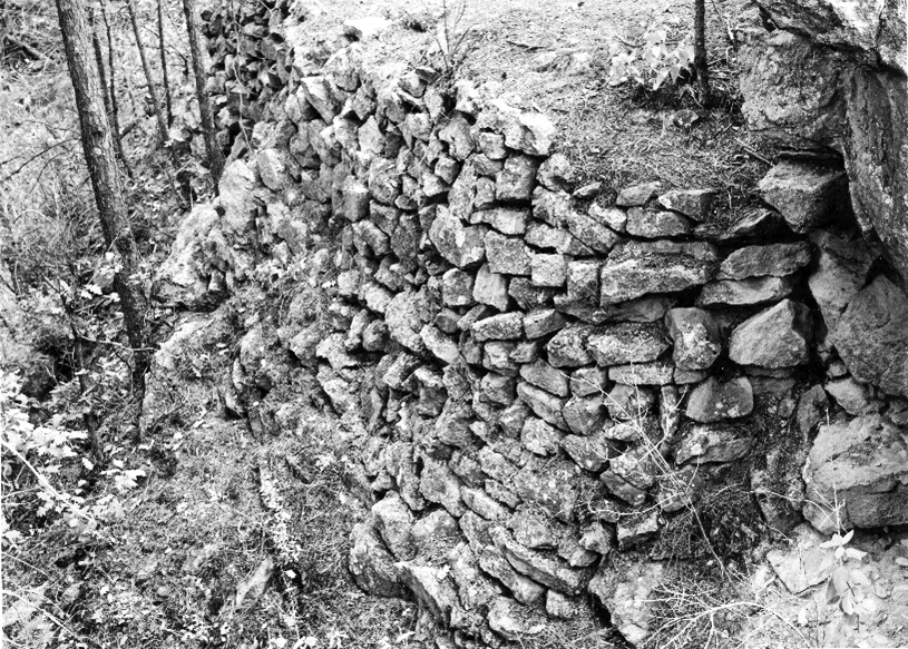 A rock support wall along Ranch School trail. Photo by Lawrence Campbell
 This switchback along the Ranch School trail involved cutting away a solid rock wall. Photo by Robert Dryja
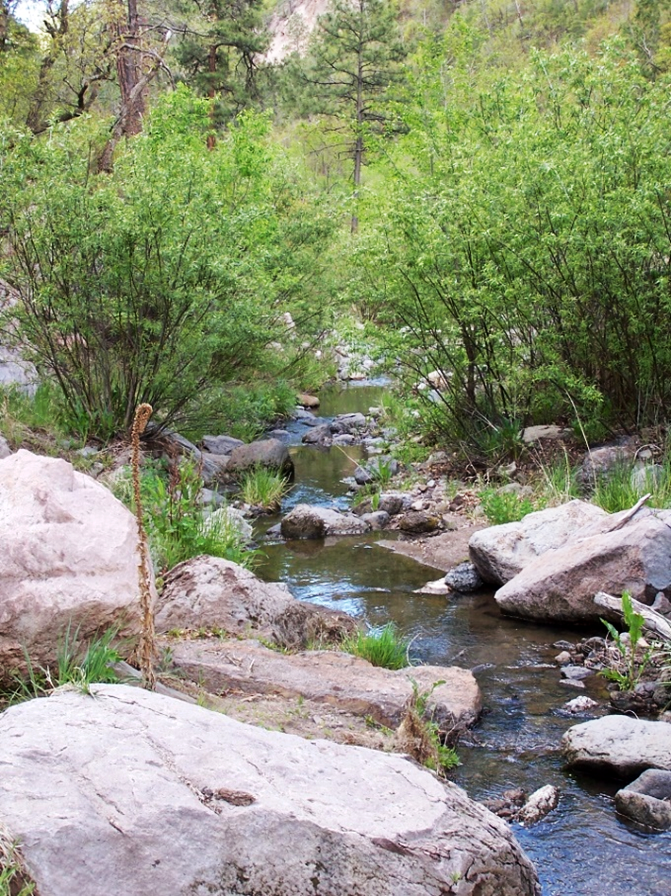 Water from snow melt and a spring create a temporary flowing creek with clear water at the intersection of Acid and Pueblo canyons. Photo by Robert Dryja
CAMP HAMILTON TRAIL
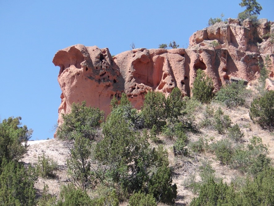
 Ranch School boys would have passed tent rock formations along Pueblo Canyon when going to the Camp Hamilton cabin. Photo by Robert Dryja
 The log cabin at Camp Hamilton in its early years was adjacent to an aspen grove. Courtesy photo
 The rock formation becomes dramatic when the trail begins its assent to the top of Los Alamos Mesa. Photo by Robert Dryja