
 Courtesy/NWS
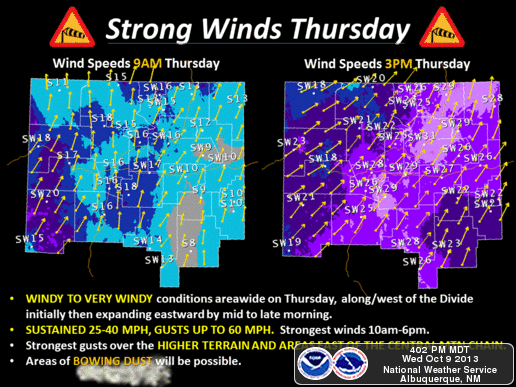
NWS News:
The National Weather Service anticipates another vigorous early season cold front to usher in strong wind, cooler temperatures and northern mountain snow. The main impact period is mid-morning to mid-evening today. Wind impacts are expected areawide with accumulating snow limited to the highest terrain of north-central and northwest New Mexico and generally above 9,500 feet.
Key Impacts:
- Windy to very windy conditions to expand across the area Thursday
- Potentially damaging wind gusts (up to 60 mph) possible higher terrain and areas to the lee of the central mountain chain as well as the northeast highlands .
- High wind warnings and wind advisories posted.
- Two-4” of snow generally expected for the northern high terrain above 9000 feet with locally up to 7” above 10,000 feet.
Overview:
A vigorous upper level storm system will brush northern New Mexico Thursday and Thursday evening while the associated cold front pushes west to east across the northern two-thirds of New Mexico during the day Thursday. Wind impacts will quickly ramp up across far western areas Thursday morning, expanding eastward by midday/early afternoon. Accumulating snow most likely in the northern mountains between 3 p.m. Thursday and 3 a.m. Friday.
Confidence:
High confidence on timing of significant wind impacts. Lower confidence on precipitation coverage with significant travel impacts related to snow expected north of the area across the higher terrain of southwest Colorado.
For More Info:
Visit www.weather.gov/abq or http://mobile.weather.gov.