
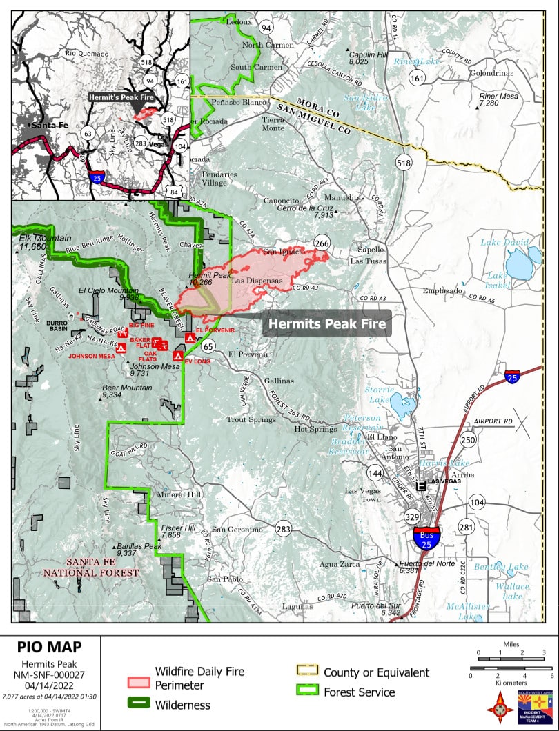
 Hermits Peak Fire PIO Map. Courtesy photo
SFNF News:
Update on Hermits Peak Fire.
Start Date: April 6, 2022
Acres: 7,077 acres
Location: Approx. 12 miles northwest of Las Vegas, NM, Pecos/Las Vegas Ranger District, Hermits Peak/Pecos Wilderness
Cause: Multiple spot fires spread beyond the prescribed fire project boundary
Fuels: Mixed conifer
Containment: 10 percent
Total personnel: 520
Highlights: As a result of firefighter efforts, availability of aircraft, and more favorable weather conditions, the Hermits Peak Fire experienced noticeably smaller growth on Wednesday. Communities in “Go” status remained unchanged as fire crews worked to build and reinforce containment lines and structure defenses. A recorded update discussing recent fire activity, status of community evacuations, road closures, and the structure damage assessment is now available on the Santa Fe National Forest Facebook page: https://www.facebook.com/santafeNF/.
Operations: Although fire spread was limited on Wednesday, there is still potential for increased activity so the firefighters will remain vigilant in their efforts to suppress the fire. As the winds moderate, firefighting aircraft have begun to support operations on the ground with water drops and reconnaissance flights. Additional crews, a variety of heavy equipment, and 20 engines have arrived on the incident, with more resources expected to join the efforts in the coming days. Firefighters are continuing to evaluate and minimize risks to structures in the surrounding communities. Crews have successfully used bulldozers to construct and improve control lines around the eastern and northern perimeters of the fire. Southwest Team 4 will transfer command of the Hermits Peak Fire to the Southwest Area Type 1 Incident Management Team 1 at 6 a.m., April 15. This is the final update from Southwest Team 4. The Team extends its sincere thanks to the local communities for their support and hospitality throughout this incident.
Evacuations:
The San Miguel County Sheriff’s Office has issued several evacuation orders using the Ready, Set, Go! system.
Areas in “Go” status (i.e., residents should be evacuating):
Las Dispensas, Pendaries Village, San Ignacio, Las Tusas, Lone Pine Mesa, Canoncito, La Canada, Manuelitas, Lower Canyon Road in Gallinas Canyon and La Tewa, Chavez, County A3, Southwest Sapello, and Southern Tierra Monte-Canyon.
Areas in “Set” status (i.e., residents should be preparing for a potential evacuation):
Upper Rociada, Rociada, Pendaries Valley East, Penasco Blanco, South Carmen, Northern Tierra Monte-Canyon, Big Pine, Canovas Canyon, El Porvenir, Gallinas, Trout Springs, Northeast and Southeast Sapello, and Los Alamitos.
An evacuation shelter is available at the Old Memorial Middle School gym at the corner of Legion and Old National in Las Vegas.
Weather: The storm system that brought an extended period of very strong winds has finally moved out of the region. Today, skies will stay generally clear with a sharp rise in temperatures near 60 degrees. Very dry air will remain in place with westerly winds through the weekend. Although trending slightly lighter, winds will remain breezy in the afternoons. The combination of dry and breezy conditions will continue the elevated fire weather conditions, resulting in the sixth Red Flag Warning in a row.
Restrictions: The Santa Fe National Forest has issued a closure order to protect public health and safety during fire operations on the Hermits Peak Fire. The full closure order and map are available at https://www.fs.usda.gov/main/santafe/home. A temporary flight restriction (TFR) is in place over the area, which includes unmanned aircraft, or drones. More information on the dangers drones pose to wildland firefighting aircraft and personnel on the ground can be found at: www.nifc.gov/drones.
Smoke: Smoke from the Hermits Peak Fire may be visible from Gallinas, El Porvenir, San Pablo, Mineral Hill, San Geronimo, Gascon, Pendaries, Rociada, Mora, Ledoux, Las Vegas, and along the I-25 corridor. Smoke-sensitive individuals and people with respiratory problems or heart disease are encouraged to take precautionary measures. An interactive smoke map at https://fire.airnow.gov/ allows you to zoom into your area to see the latest smoke conditions.
Future Fire Information: The Hermits Peak Fire Information office hours (8 a.m. to 8 p.m.), phone number (505.663.6334), and email address (2022.hermitspeak@firenet.gov) will remain the same after the transition to the Type 1 Team. Future fire information will continue to be posted on Inciweb, the SFNF Facebook and Twitter, SFNF website, and New Mexico Fire Information website.